
Fail:Europe 814.svg

Algfail (SVG-fail, algsuurus 1399 × 919 pikslit, faili suurus: 3,4 MB)
| See fail ja sellest kastist allapoole jääv kirjeldus pärinevad kesksest failivaramust Wikimedia Commons. | Faili lehekülg Commonsis |
Lühikirjeldus
| Kirjeldus |
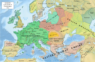
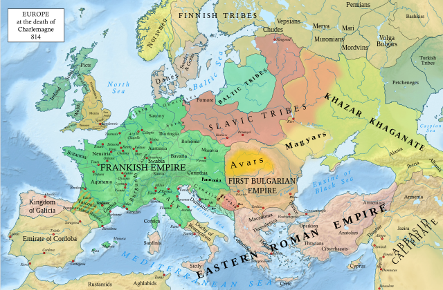
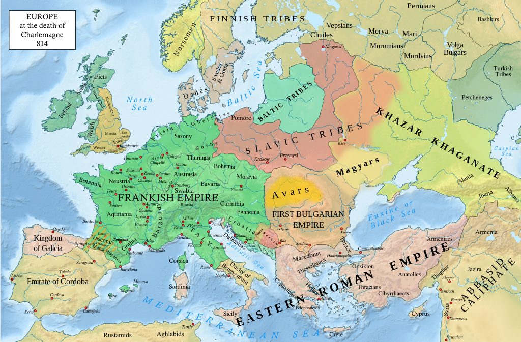
English: An svg version of File:Europe 814.jpg with corrections.
List of corrections:
|
| Kuupäev | |
| Allikas | "The Public Schools Historical Atlas" by Charles Colbeck. Longmans, Green; New York; London; Bombay. 1905. |
| Autor | Hel-hama |
| Teised versioonid |
|


_en.png)
.png)
.jpg)
Litsents
- Tohid:
- jagada – teost kopeerida, levitada ja edastada
- kohandada – valmistada muudetud teoseid
- Järgmistel tingimustel:
- omistamine – Pead materjali sobival viisil autorile omistama, tooma ära litsentsi lingi ja märkima ära, kas on tehtud muudatusi. Sobib, kui teed seda mõistlikul viisil, kuid seejuures ei tohi jääda muljet, et litsentsiandja tõstab esile sind või seda, et sina materjali kasutad.
- sarnaselt jagamine – Kui töötled, kujundad ümber või arendad materjali edasi, siis pead oma töö levitamiseks kasutama sama litsentsi, mille all on algupärand, või ühilduvat litsentsi.
See teos on Ameerika Ühendriikides avalikus omandis. See käib Ameerika Ühendriikide teoste kohta, mille autoriõigus on aegunud. Põhjuseks võib olla teose avaldamine enne 1. jaanuari 1929. aastal. Täpsema teabe leiad sellelt leheküljelt.
|
 | |
 |
Väljaspool Ameerika Ühendriike ei pruugi see pilt avalikus omandis olla (eriti riikides, nagu Hiina (välja arvatud Hongkong ja Aomen), Kanada, Mehhiko, Saksamaa ja Šveits, kus Ameerika Ühendriikide teostele ei kohaldu lühem autoriõiguse kehtivus). Autor ja avaldamisaasta peavad pildi juures märgitud olema. Täiendava teabe jaoks vaata lehekülgi Wikipedia:Public domain ja Wikipedia:Copyrights.
|
.svg)
|
This file is licensed under the Open Government Licence version 1.0 (OGL v1.0).
|
|---|---|
|
You are free to:
See the Open Government Licence page on Meta-Wiki for more information.
|
This work is in the public domain in India because its term of copyright has expired.
The Indian Copyright Act applies in India to works first published in India. According to the Indian Copyright Act, 1957, as amended up to Act No. 27 of 2012 (Chapter V, Section 25):
|
 |
Faili ajalugu
Klõpsa kuupäeva ja kellaaega, et näha sel ajahetkel kasutusel olnud failiversiooni.
| Kuupäev/kellaaeg | Pisipilt | Mõõtmed | Kasutaja | Kommentaar | |
|---|---|---|---|---|---|
| viimane | 8. jaanuar 2023, kell 23:05 | | 1399 × 919 (3,4 MB) | Miki Filigranski | correction of Bosnian border, which was a separate land according to modern scholarship, contested but never completelly under Serbian or Croatian control |
| 30. november 2022, kell 00:32 |  | 1399 × 919 (3,39 MB) | Gyalu22 | Added Avar ethnic territory, see Bulgarians_and_Slavs_VI-VII_century.png. Also extended Magyar ethnic territory to Bessarabia | |
| 1. november 2022, kell 13:26 |  | 1399 × 919 (3,38 MB) | Miki Filigranski | Reverted to version as of 07:20, 31 July 2022 (UTC) | |
| 3. august 2022, kell 07:47 |  | 1399 × 919 (3,38 MB) | Bernd21t | (muudatuse resümee eemaldatud) | |
| 31. juuli 2022, kell 10:20 |  | 1399 × 919 (3,38 MB) | Miki Filigranski | Reverted to version as of 16:51, 27 March 2022 (UTC) | |
| 18. juuli 2022, kell 08:13 |  | 1399 × 919 (3,38 MB) | Ionelen | Reverted to version as of 19:41, 13 April 2022 (UTC) | |
| 12. juuli 2022, kell 10:41 |  | 1399 × 919 (3,38 MB) | Ahmet Q. | Reverted to version as of 16:51, 27 March 2022 (UTC) | |
| 13. aprill 2022, kell 22:41 |  | 1399 × 919 (3,38 MB) | Wojsław12 | Reverted to version as of 11:43, 14 January 2022 (UTC) | |
| 27. märts 2022, kell 19:51 |  | 1399 × 919 (3,38 MB) | Silverije | Reverted to version as of 12:43, 1 June 2021 (UTC) | |
| 14. jaanuar 2022, kell 14:43 |  | 1399 × 919 (3,38 MB) | TómasdeAquino2 | Corrected POV issues of blocked sock of Crovata Miki Filigranski |
Faili kasutus
Seda faili kasutavad järgmised 2 lehekülge:
Globaalne failikasutus
Järgmised muud vikid kasutavad seda faili:
- Faili kasutus vikis af.wikipedia.org
- Faili kasutus vikis ar.wikipedia.org
- Faili kasutus vikis arz.wikipedia.org
- Faili kasutus vikis bg.wikipedia.org
- Faili kasutus vikis bn.wikipedia.org
- Faili kasutus vikis ca.wikipedia.org
- Faili kasutus vikis cs.wikipedia.org
- Faili kasutus vikis cy.wikipedia.org
- Faili kasutus vikis de.wikipedia.org
- Faili kasutus vikis el.wikipedia.org
- Faili kasutus vikis en.wikipedia.org
- Charlemagne
- History of Europe
- Vikings
- 814
- History of Estonia
- Bulgars
- Principality of Serbia (early medieval)
- Saare County
- Early Middle Ages
- Kvenland
- Askold and Dir
- Duchy of Benevento
- Portal:Estonia
- Franks
- Višeslav of Serbia
- History of Christian thought on persecution and tolerance
- Borna (duke)
- Vlastimir
- Arab–Khazar wars
- Duchy of Gascony
- Muslim conquest of Sicily
- Prosigoj
- Rus' people
- Early Slavs
- Radoslav of Serbia
- Barbarian kingdoms
- Agriculture in the Middle Ages
- Gersuinda
- User:Falcaorib
- Faili kasutus vikis en.wikibooks.org
Vaata selle faili globaalset kasutust.