
Fail:Abbasid Caliphate 891-892.png

Selle eelvaate suurus: 800 × 382 pikslit. Teised eraldusvõimed: 320 × 153 pikslit | 640 × 306 pikslit | 1024 × 490 pikslit | 1280 × 612 pikslit | 3054 × 1460 pikslit.
Algfail (3054 × 1460 pikslit, faili suurus: 1,44 MB, MIME tüüp: image/png)
| See fail ja sellest kastist allapoole jääv kirjeldus pärinevad kesksest failivaramust Wikimedia Commons. | Faili lehekülg Commonsis |
Lühikirjeldus
| Kirjeldus |
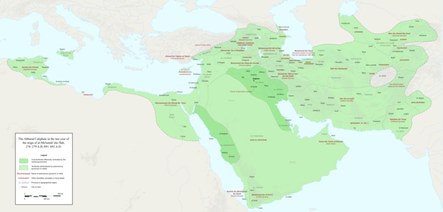
English: Map of the Abbasid Caliphate at the end of the reign of al-Mu'tamid in 891-892. Dark green denotes provinces under the effective control of the central government; light green denotes provinces under the control of autonomous governors or rebels.
The core Abbasid territories include Shahrazur, Darabadh, al-Samaghan, Hulwan, Masabadhan, Mihrijanqadhaq, the Euphrates districts, and Qarqisiyya (al-Tabari v. 37, p. 98; Bianquis p. 96). Map originally created as an .SVG file in Inkscape and converted to .PNG for size reasons. Background topography taken from DEMIS Mapserver, which are public domain. Works Cited:
|
| Kuupäev | |
| Allikas | Üleslaadija oma töö |
| Autor | Ro4444 |
| Teised versioonid |
 |
Litsents
Autoriõiguse omanikuna avaldan selle teose järgmise litsentsi all:
See fail kuulub Creative Commonsi rahvusvahelise litsentsi "Autorile viitamine + jagamine samadel tingimustel 4.0" alla.
- Tohid:
- jagada – teost kopeerida, levitada ja edastada
- kohandada – valmistada muudetud teoseid
- Järgmistel tingimustel:
- omistamine – Pead materjali sobival viisil autorile omistama, tooma ära litsentsi lingi ja märkima ära, kas on tehtud muudatusi. Sobib, kui teed seda mõistlikul viisil, kuid seejuures ei tohi jääda muljet, et litsentsiandja tõstab esile sind või seda, et sina materjali kasutad.
- sarnaselt jagamine – Kui töötled, kujundad ümber või arendad materjali edasi, siis pead oma töö levitamiseks kasutama sama litsentsi, mille all on algupärand, või ühilduvat litsentsi.
Faili ajalugu
Klõpsa kuupäeva ja kellaaega, et näha sel ajahetkel kasutusel olnud failiversiooni.
| Kuupäev/kellaaeg | Pisipilt | Mõõtmed | Kasutaja | Kommentaar | |
|---|---|---|---|---|---|
| viimane | 4. detsember 2017, kell 02:18 | | 3054 × 1460 (1,44 MB) | Ro4444 | Further color corrections |
| 4. detsember 2017, kell 01:50 |  | 3054 × 1460 (1,44 MB) | Ro4444 | Color correction | |
| 4. detsember 2017, kell 00:11 |  | 3054 × 1460 (1,44 MB) | Ro4444 | User created page with UploadWizard |
Faili kasutus
Seda faili kasutavad järgmised 3 lehekülge:
Globaalne failikasutus
Järgmised muud vikid kasutavad seda faili:
- Faili kasutus vikis ar.wikipedia.org
- Faili kasutus vikis de.wikiversity.org
- Faili kasutus vikis en.wikipedia.org
- Faili kasutus vikis en.wikibooks.org
- Faili kasutus vikis fa.wikipedia.org
- Faili kasutus vikis hy.wikipedia.org
- Faili kasutus vikis id.wikipedia.org
- Faili kasutus vikis ja.wikipedia.org
- Faili kasutus vikis no.wikipedia.org
- Faili kasutus vikis pt.wikipedia.org
- Faili kasutus vikis sco.wikipedia.org
- Faili kasutus vikis uk.wikipedia.org
- Faili kasutus vikis uz.wikipedia.org
- Faili kasutus vikis zh.wikipedia.org