
Fail:UE Soils.png

Selle eelvaate suurus: 800 × 575 pikslit. Teised eraldusvõimed: 320 × 230 pikslit | 640 × 460 pikslit | 1024 × 736 pikslit | 1280 × 920 pikslit | 2560 × 1841 pikslit | 2872 × 2065 pikslit.
Algfail (2872 × 2065 pikslit, faili suurus: 364 KB, MIME tüüp: image/png)
| See fail ja sellest kastist allapoole jääv kirjeldus pärinevad kesksest failivaramust Wikimedia Commons. | Faili lehekülg Commonsis |
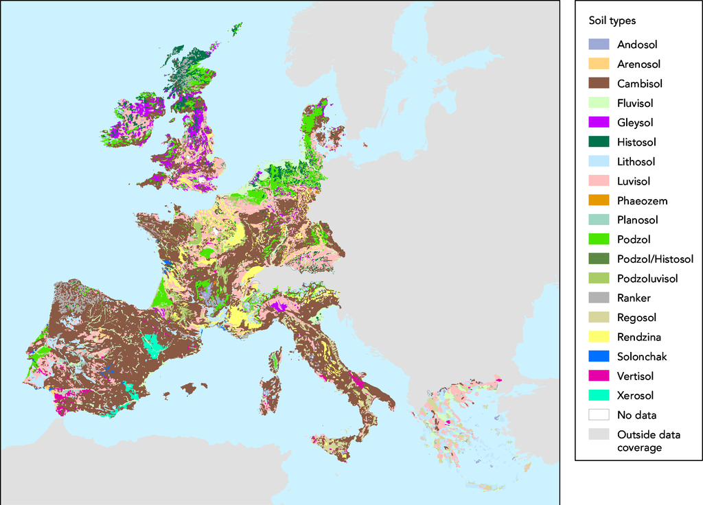
- Source :
- The map was made on data in GISCO delivery 12-2002 which was slightly revised compared to the available dataset (GISCO delivery 09-2000).
- Date:
- 05/03/2003
- Keyword(s):
- desertification,soil,geographic,DISMED Natlan.
- Type:
- Map
- Technical producer:
- European Environment Agency
- http://www.eea.eu.int archive copy at the Wayback Machine
- View the full description here:
This image is in the public domain because it is extracted from the European Environment Agency Website, whose material is in the public domain unless otherwise stated (see the copyright notice). Online access: www.eea.eu.int
This is valid despite the copyright notice at the bottom of each page, see this confirmation e-mail. | |
Faili ajalugu
Klõpsa kuupäeva ja kellaaega, et näha sel ajahetkel kasutusel olnud failiversiooni.
| Kuupäev/kellaaeg | Pisipilt | Mõõtmed | Kasutaja | Kommentaar | |
|---|---|---|---|---|---|
| viimane | 27. november 2005, kell 18:44 | | 2872 × 2065 (364 KB) | Tvpm | *Source : ::The map was made on data in GISCO delivery 12-2002 which was slightly revised compared to the available dataset (GISCO delivery 09-2000). *Date: ::05/03/2003 *Keyword(s): ::desertification,soil,geographic,DISMED Natlan. *Type: ::Map *Technical |
Faili kasutus
Seda faili kasutab järgmine lehekülg:
Globaalne failikasutus
Järgmised muud vikid kasutavad seda faili:
- Faili kasutus vikis ca.wikipedia.org
- Faili kasutus vikis de.wikipedia.org
- Faili kasutus vikis fr.wikipedia.org
- Faili kasutus vikis nl.wikipedia.org