
Fail:Sediment Sloshes in Solway Firth.jpg

Algfail (3860 × 2849 pikslit, faili suurus: 2,53 MB, MIME tüüp: image/jpeg)
| See fail ja sellest kastist allapoole jääv kirjeldus pärinevad kesksest failivaramust Wikimedia Commons. | Faili lehekülg Commonsis |
Lühikirjeldus
| Kirjeldus |
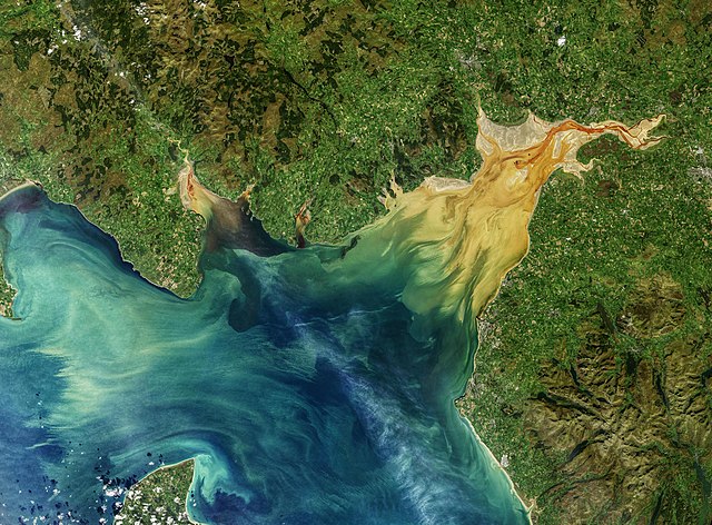
Fjords and funnel-shaped bays and inlets are often scenes of dramatic tidal changes; the Bay of Fundy is perhaps the world’s most spectacular example. This sloshing of water into and out of basins can produce visible surges of sediment and floating debris, turbulent mixing of fresh and salty waters, and sometimes distinct lines between different water masses. That was the case in October 2019 when the Operational Land Imager on the Landsat 8 satellite captured the data for this image of Solway Firth. On that day, the waters along the coast of Dumfries and Galloway, Scotland, and Cumbria, England, were rich with sediment and dissolved organic matter (plant debris, soils, plankton) that was likely stirred up by the tides. The water changes color abruptly offshore where the shallower bay meets deeper waters of the Irish Sea. The image above is a blend of art and science. Like a photographer who adjusts lighting and uses filters, Norman Kuring of NASA’s Ocean Biology group works with various software programs and color-filtering techniques to draw out the fine details in the water. The swirls and streamers in Solway Firth are real, but Kuring has separated and enhanced certain shades and tones in the data to make the sediments and dissolved organic matter stand out. (Click here for a natural-color view at lower resolution.) On a sandy shoal offshore, a pattern of symmetrical white dots and shadows marks the location of the Robin Rigg wind farm. Sediment plumes make thin lines across the water toward the east-northeast, suggesting either strong winds blowing out of the southwest or the inflow of tidal currents toward the coast. Robin Rigg was Scotland’s first offshore wind farm, coming online in 2010. It can generate up to 174 megawatts of power, enough to supply 117,000 homes. Solway Firth is the United Kingdom’s third-largest estuary, and it is lined by beaches, coastal dunes, and salt marshes, a few of which are special conservation areas. The lands around the firth are mostly rural and agricultural. Along with its natural beauty, the region is rich with history—including the western end of Hadrian’s Wall, which terminates on the firth’s southern shore. |
| Kuupäev | |
| Allikas | https://earthobservatory.nasa.gov/images/145958/sediment-sloshes-in-solway-firth |
| Autor | NASA images by Norman Kuring/NASA's Ocean Color Web, using Landsat data from the U.S. Geological Survey. Story by Michael Carlowicz. |
|
Litsents
| See fail on avalikus omandis, sest selle autori NASA autoriõiguspõhimõtte järgi ei ole ilma vastava märketa NASA materjalid autoriõigusega kaitstud. (NASA autoriõiguspõhimõtted või JPL-i piltide kasutuspõhimõtted). | ||
 |
Hoiatused:
|
Faili ajalugu
Klõpsa kuupäeva ja kellaaega, et näha sel ajahetkel kasutusel olnud failiversiooni.
| Kuupäev/kellaaeg | Pisipilt | Mõõtmed | Kasutaja | Kommentaar | |
|---|---|---|---|---|---|
| viimane | 1. veebruar 2021, kell 20:41 | | 3860 × 2849 (2,53 MB) | StellarHalo | {{Information |Description=Fjords and funnel-shaped bays and inlets are often scenes of dramatic tidal changes; the Bay of Fundy is perhaps the world’s most spectacular example. This sloshing of water into and out of basins can produce visible surges of sediment and floating debris, turbulent mixing of fresh and salty waters, and sometimes distinct lines between different water masses. That was the case in October 2019 when the Operational Land Imager on the Landsat 8 satellite captured the... |
Faili kasutus
Seda faili kasutab järgmine lehekülg:
Globaalne failikasutus
Järgmised muud vikid kasutavad seda faili:
- Faili kasutus vikis en.wikipedia.org
- Faili kasutus vikis fr.wikipedia.org
- Faili kasutus vikis pl.wikipedia.org
- Faili kasutus vikis sv.wikipedia.org
- Faili kasutus vikis www.wikidata.org