
Fail:Madagascar 1616, Jodocus Hondius (4262495-recto).png

Algfail (2281 × 1597 pikslit, faili suurus: 5,86 MB, MIME tüüp: image/png)
| See fail ja sellest kastist allapoole jääv kirjeldus pärinevad kesksest failivaramust Wikimedia Commons. | Faili lehekülg Commonsis |
Lühikirjeldus
| Kirjeldus |
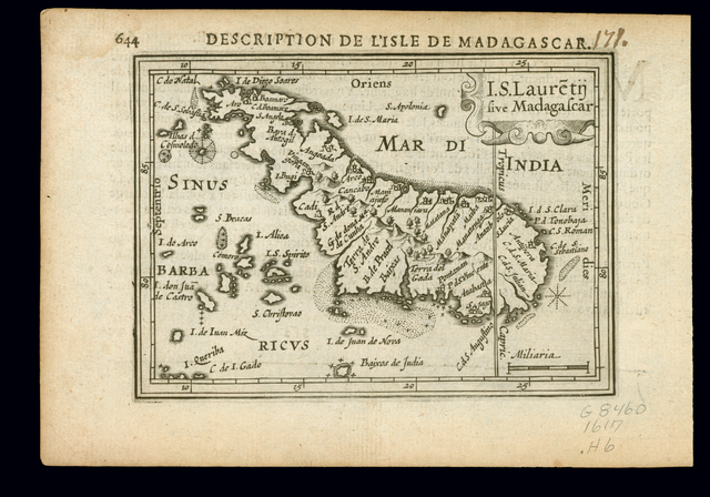
English: I.S. Lauretij sive Madagascar. Description de l'isle de Madagascar. Description du royaume Mosambique. Relief shown pictorially. Map oriented with north to the left. Detached from a French edition of Tabularum geographicarum contractarum ..., by Petrus Bertius, p. 644 (map) and 643 (text). (Description from: Fedora Library.) |
|||||||||||||||||||||||||||||||||||||||||||
| Kuupäev | ||||||||||||||||||||||||||||||||||||||||||||
| Allikas | North West University Library, 16th-20th Century Maps of Africa, #4262495 | |||||||||||||||||||||||||||||||||||||||||||
| Autor |
|
|||||||||||||||||||||||||||||||||||||||||||
| Teised versioonid |
|
|||||||||||||||||||||||||||||||||||||||||||


.png)
.png?uselang=et)
Litsents
This image is in the public domain because it is a mere mechanical scan or photocopy of a public domain original, or – from the available evidence – is so similar to such a scan or photocopy that no copyright protection can be expected to arise. The original itself is in the public domain for the following reason:
This tag is designed for use where there may be a need to assert that any enhancements (eg brightness, contrast, colour-matching, sharpening) are in themselves insufficiently creative to generate a new copyright. It can be used where it is unknown whether any enhancements have been made, as well as when the enhancements are clear but insufficient. For known raw unenhanced scans you can use an appropriate {{PD-old}} tag instead. For usage, see Commons:When to use the PD-scan tag.  | ||||
Faili ajalugu
Klõpsa kuupäeva ja kellaaega, et näha sel ajahetkel kasutusel olnud failiversiooni.
| Kuupäev/kellaaeg | Pisipilt | Mõõtmed | Kasutaja | Kommentaar | |
|---|---|---|---|---|---|
| viimane | 24. oktoober 2009, kell 07:41 | | 2281 × 1597 (5,86 MB) | Martin H. | == {{int:filedesc}} == {{Information |Description= ;I.S. Lauretij sive Madagascar. ''Description de l'isle de Madagascar''<br/> ''Description du royaume Mosambique'' Relief shown pictorially. Map oriented with north to the left. Detached from a French ed |
Faili kasutus
Seda faili kasutab järgmine lehekülg:
Globaalne failikasutus
Järgmised muud vikid kasutavad seda faili:
- Faili kasutus vikis be.wikipedia.org
- Faili kasutus vikis pl.wikipedia.org
- Faili kasutus vikis vi.wikipedia.org
.png)