
Fail:1794 Boulton and Anville Wall Map of Africa (most important 18th cntry map of Africa) - Geographicus - Africa2-boulton-1794.jpg
Algfail (5988 × 5025 pikslit, faili suurus: 7,99 MB, MIME tüüp: image/jpeg)
| See fail ja sellest kastist allapoole jääv kirjeldus pärinevad kesksest failivaramust Wikimedia Commons. | Faili lehekülg Commonsis |
Lühikirjeldus
| Pealkiri |
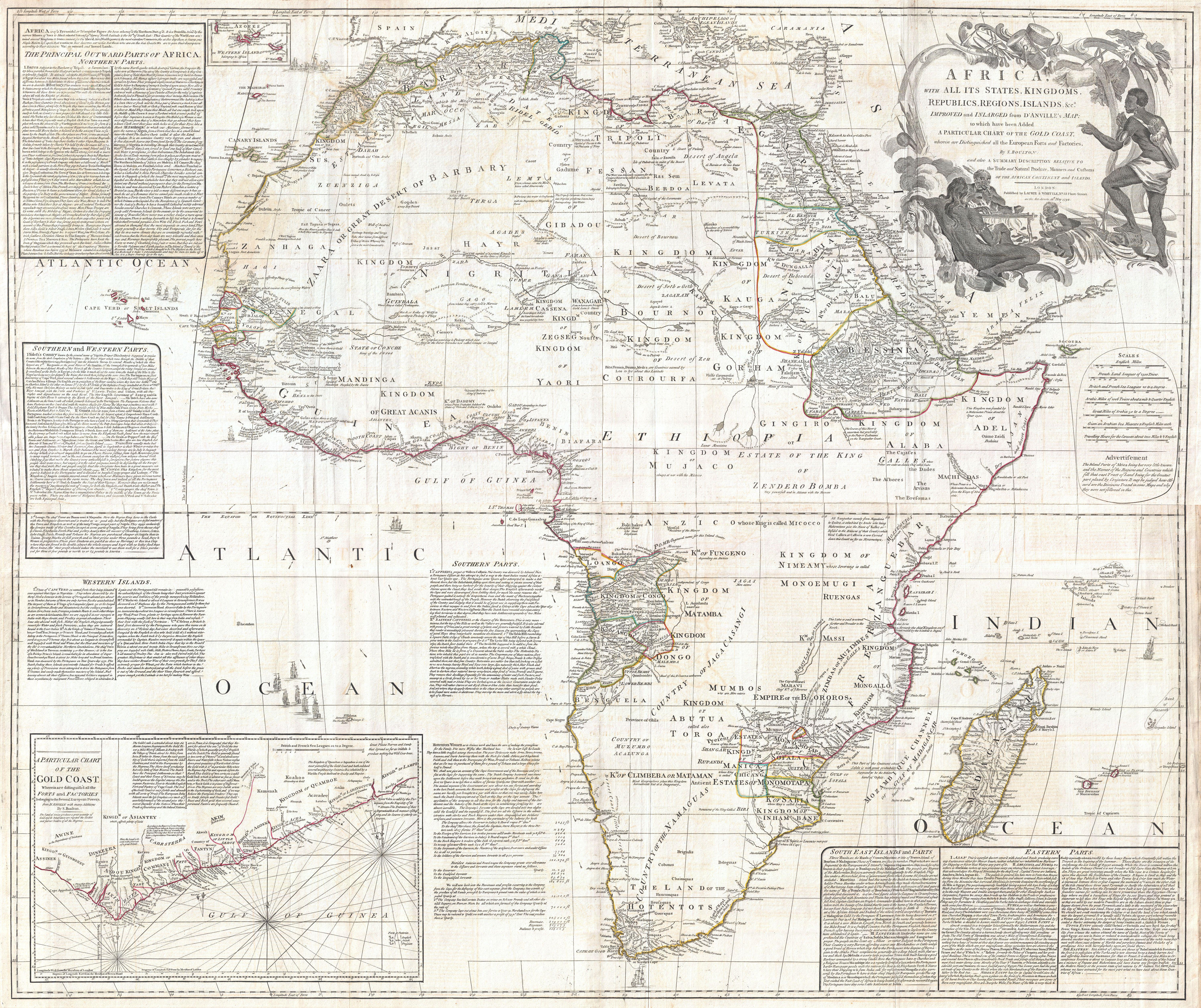
Africa, with all its States, Kingdoms, Republics, Regions, Islands, & cca. Improved and Inlarged from D’Anville’s Map: to which has been added A Particular Chart of the Gold Coast wherein are Distinguished all the European Forts, and Factories, by S. Boulton: and also A Summary Description relative to the Trade adn Natural Produce, Manners and Customs of the African Continent and Islands. |
||||||||||||||||||||||||||||||||||||
| Kirjeldus |
English: This is probably the most important map of Africa produced in the 18th century. Largely based upon the earlier D’Anville map, this map has been enlarged and expanded by Samuel Boulton. Depicts the continent in full with insets of the Gold Coast (or Ivory Coast, or Guinea). This map is unique in that it is a serious attempt to compile all of the accurate scientific knowledge of the African continent available at the time. In contrast to many other Africa maps of the period there's almost no attempt to fill the “unknown” regions of the interior with fictitious beasts, kingdoms, and geological features. Boulton himself advertises “The inland parts of Africa being but very little known and the names of the regions and countries which fill that vast tract of land being for the greatest part placed by conjecture it may be judged how absurd are the divisions traced in some maps and why they are not followed in this.“ Despite this, this map actually does provide a wealth of information both in the form of a gazetteer printed in framed text boxes here and there on the map, as well as political and geographical features.
This map bears up to almost endless perusal and volumes could be composed on its content. The cartographer attempts to depict both known and unknown parts of the continent with actual data reported by both contemporary and ancient travelers. In most cases it is extremely difficult to identify specific sources as much of the data is vague and uncertain. Boulton for example notes a community of Jews near what would today be Mali. Though a very small community of Jewish traders did live in Mali in the 15th century, most had been killed or converted to Islam by the 16th century. No doubt Boulton's sources here were extremely archaic. Boulton also relies heavily on the geography of Claudius Ptolemy, noting this source in numerous notations which range from commentary on local peoples to the courses of important river systems. Clearly much of the map is focused on commerce and where information is available, Boulton makes notes on local commercial products and mineral wealth. There are also copious notations on caravan routes, especially those routes which were known to offer caravan transverse of the Sahara. Generally following Ptolemy, Boulton includes a number of mysterious river systems which seem to appear out of nowhere and run to nowhere. With regard to the White Nile, which he presumes correctly to be greater than the Blue Nile, he follows the ancient two lakes at the base of the Mountains of the Moon theory. In the southern half of Africa there is considerably less information on the interior save for those lands mapped by the Portuguese along the Congo and Zambezi Rivers. The regions around the Zambezi, called Monomotapa, are particularly interesting as many considered this area to be the Biblical land of Ophir, where one could discover the mines of King Solomon. Just north of Monomotapa we find an embryonic representation of Lake Malawi, here called Maravi. In South Africa the Dutch Company is strongly established and the region is well mapped well into the interior.Español: Este es posiblemente el más importante mapa de África elaborado en el siglo XVIII. Basado en gran parte en el mapa anterior de D’Anville, este mapa ha sido ampliado por Samuel Boulton. Muestra el continente en su totalidad con inserciones de la Costa del Oro (o Costa de Marfil o Guinea). Este mapa se destaca como un intento serio de compilar todo el conocimiento científico del continente africano disponible en ese momento.
Українська: Це, мабуть, найважливіша карта Африки, створена у 18 столітті. Значною мірою базуючись на попередній карті д’Анвіля, ця карта була збільшена та розширена Соломоном Болтоном. Зображує континент повністю зі вставками Золотого Берегу (або Кот-д'Івуару та Гвінеї). Ця карта унікальна тим, що є серйозною спробою зібрати всі точні наукові знання про африканський континент, доступні на той час. |
||||||||||||||||||||||||||||||||||||
| Kuupäev | |||||||||||||||||||||||||||||||||||||
| Allikas |
Kitchin, Thomas, Kitchin's General Atlas, describing the Whole Universe: being a complete collection of the most approved maps extant; corrected with the greatest care, and augmented from the last edition of D'Anville and Robert with many improvements by other eminent geographers, engraved on Sixty-Two plates, comprising Thirty Seven maps., Laurie & Whittle, London, 1797.
|
||||||||||||||||||||||||||||||||||||
| Looja |
|
||||||||||||||||||||||||||||||||||||
| Geotemporal data | |||||||||||||||||||||||||||||||||||||
| Map location | Aafrika | ||||||||||||||||||||||||||||||||||||
| Georeferencing | If inappropriate please set warp_status = skip to hide. | ||||||||||||||||||||||||||||||||||||
| Bibliographic data | |||||||||||||||||||||||||||||||||||||
| Keel | inglise | ||||||||||||||||||||||||||||||||||||
| Kirjastaja |
Laurie & Whittle |
||||||||||||||||||||||||||||||||||||
| Archival data | |||||||||||||||||||||||||||||||||||||
| Inventarinumber |
Geographicus link: Africa2-boulton-1794 |
||||||||||||||||||||||||||||||||||||
| Mõõtmed | kõrgus: 41 tolli (104,1 cm); laius: 49 tolli (124,4 cm) | ||||||||||||||||||||||||||||||||||||
| Teised versioonid |
|
||||||||||||||||||||||||||||||||||||

_-_Geographicus_-_Africa2-boulton-1794_A_001.jpg)

_-_Geographicus_-_Africa2-boulton-1794.jpg?uselang=et)
Hinnang
|
_-_Geographicus_-_Africa2-boulton-1794.jpg)
See pilt valiti 2023. aasta 6. juuni päevapildiks. Pildil oli järgnev allkiri: English: This is probably the most important map of Africa produced in the 18th century. Largely based upon the earlier D’Anville map, this map has been enlarged and expanded by Samuel Boulton. Depicts the continent in full with insets of the Gold Coast (or Ivory Coast, or Guinea). This map is unique in that it is a serious attempt to compile all of the accurate scientific knowledge of the African continent available at the time. Teistes keeltes:
Čeština: Toto je pravděpodobně nejdůležitější mapa Afriky, vytvořená v 18. století. Byla z velké části založena na dřívější mapě francouzského kartografa Jean-Baptiste Bourguignon d'Anvilla, kterou však zvětšil a rozšířil Solomon Boulton. Zobrazuje celý kontinent i s oblastmi Pobřeží slonoviny nebo Guineou a představuje pokus spojit všechny přesné vědecké poznatky o africkém kontinentu dostupné v té době. Deutsch: Karte von Afrika aus dem Jahr 1794 von Samuel Boulton. Basierend auf der Arbeit von d’Anville integriert Boulton alle zu seiner Zeit bekannten Fakten in seinem Werk. English: This is probably the most important map of Africa produced in the 18th century. Largely based upon the earlier D’Anville map, this map has been enlarged and expanded by Samuel Boulton. Depicts the continent in full with insets of the Gold Coast (or Ivory Coast, or Guinea). This map is unique in that it is a serious attempt to compile all of the accurate scientific knowledge of the African continent available at the time. Español: Este es posiblemente el más importante mapa de África elaborado en el siglo XVIII. Basado en gran parte en el mapa anterior de D’Anville, este mapa ha sido ampliado por Samuel Boulton. Muestra el continente en su totalidad con inserciones de la Costa del Oro (o Costa de Marfil o Guinea). Este mapa se destaca como un intento serio de compilar todo el conocimiento científico del continente africano disponible en ese momento. Français : Carte de l'Afrique dessinée au XVIIIe siècle à partir d'une ancienne carte de Bourguignon d'Anville. Son caractère exceptionnel tient au fait qu'elle compile et représente tout le savoir scientifique accumulé à l'époque sur le continent africain. Italiano: Si tratta probabilmente della più importante cartina dell'Africa del XVIII secolo. Basata ampiamente sulla precedente mappa di D'Anville, essa è stata ingrandita ed estesa da Samuel Boulton. Nel disegno è raffigurato l'intero continente con inserti della Costa d'Oro (o Costa d'Avorio o Guinea). Questa cartina è unica in quanto rappresenta un serio tentativo di compilare tutte le conoscenze scientifiche sul continente africano disponibili all'epoca. Magyar: Ez a feltehetőleg a 18. században készült legfontosabb Afrika-térkép. A nagyrészt D'Anville korábbi térképén alapuló térképet Samuel Boulton nagyította ki. A kontinenst teljes egészében ábrázolja, az Aranypart (vagy Elefántcsontpart vagy Guinea) beillesztésével. Ez a térkép egyedülálló abban a tekintetben, hogy komoly kísérletet tesz az afrikai kontinensről akkoriban rendelkezésre álló összes pontos tudományos ismeret összegyűjtésére Nederlands: Achttiende-eeuwse topografische kaart van het werelddeel Afrika. Op basis van een eerdere kaart door Jean Baptiste Bourguignon d'Anville heeft Samuel Bolton getracht alle op dat moment beschikbare relevante wetenschappelijke informatie in deze kaart te verwerken. Português: Este é provavelmente o mapa mais importante da África produzido no século XVIII. Em grande parte baseado no mapa anterior de D'Anville, este mapa foi ampliado e expandido por Samuel Boulton. Retrata o continente na íntegra com inserções da Costa do Ouro (ou Costa do Marfim ou Guiné). Este mapa é único por ser uma tentativa séria de compilar todo o conhecimento científico preciso do continente africano disponível na época. Slovenščina: To je verjetno najpomembnejši zemljevid Afrike, izdelan v 18. stoletju. V veliki meri temelji na prejšnjem D'Anvillovem zemljevidu, ki ga je povečal in razširil Samuel Boulton. Prikazuje celotno celino z vstavkom Zlate obale (ali Slonokoščene obale ali Gvineje). Ta zemljevid je edinstven, saj je resen poskus zbrati vse natančno znanstveno znanje o afriški celini, ki je bilo takrat na voljo. Македонски: Најважната карта на Африка изработена во XVIII век, заснована на Ж. Б. Б. Данвил и проширена од Семјуел Бултон. Русский: Карта Африки XVIII века. Эта работа в значительной степени воспроизводилась на основе более ранней карты Жана де Анвиля. Изображает континент полностью с землями Золотого берега. Данная карта уникальна тем, что представляет наибольшую сумму всех точных научных знаний об африканском континенте, доступных в то время Українська: Це, мабуть, найважливіша карта Африки, створена у 18 столітті. Значною мірою базуючись на попередній карті д’Анвіля, ця карта була збільшена та розширена Соломоном Болтоном. Зображує континент повністю зі вставками Золотого Берегу (або Кот-д'Івуару та Гвінеї). Ця карта унікальна тим, що є серйозною спробою зібрати всі точні наукові знання про африканський континент, доступні на той час. |
Litsents
|
See on algupärase kahemõõtmelise kunstiteose tõetruu fotograafiline jäljendus. Kunstiteos ise on järgeval põhjusel avalikus omandis:
Wikimedia Sihtasutuse ametliku seisukoha järgi on avalikus omandis olevate kunstiteoste tõetruud jäljendused samuti avalikus omandis. Vastuväited sellele on vastuolus üldise ettekujutusega avalikust omandist. Vaata abilehte Commons:When to use the PD-Art tag.
Seetõttu arvatakse ka fotograafiline jäljendus avalikus omandis olevaks. Palun võta arvesse, et kohalikud seadused võivad selle materjali taaskasutamise keelata või seda piirata. Vaata abilehte Commons:Reuse of PD-Art photographs. | ||||
Faili ajalugu
Klõpsa kuupäeva ja kellaaega, et näha sel ajahetkel kasutusel olnud failiversiooni.
| Kuupäev/kellaaeg | Pisipilt | Mõõtmed | Kasutaja | Kommentaar | |
|---|---|---|---|---|---|
| viimane | 23. märts 2011, kell 07:33 | | 5988 × 5025 (7,99 MB) | BotMultichillT | {{subst:User:Multichill/Geographicus |link=http://www.geographicus.com/P/AntiqueMap/Africa2-boulton-1794 |product_name=1794 Boulton and Anville Wall Map of Africa (most important 18th cntry map of Africa) |map_title=Africa, with all its States, Kingdoms, |
Faili kasutus
Seda faili kasutab järgmine lehekülg:
Globaalne failikasutus
Järgmised muud vikid kasutavad seda faili:
- Faili kasutus vikis alt.wikipedia.org
- Faili kasutus vikis av.wikipedia.org
- Faili kasutus vikis bn.wikipedia.org
- Faili kasutus vikis cv.wikipedia.org
- Faili kasutus vikis fr.wikipedia.org
- Faili kasutus vikis ha.wikipedia.org
- Faili kasutus vikis hu.wikipedia.org
- Faili kasutus vikis it.wiktionary.org
- Faili kasutus vikis kk.wikipedia.org
- Faili kasutus vikis ko.wikipedia.org
- Faili kasutus vikis lbe.wikipedia.org
- Faili kasutus vikis lez.wikipedia.org
- Faili kasutus vikis mk.wikipedia.org
- Faili kasutus vikis os.wikipedia.org
- Faili kasutus vikis pt.wikipedia.org
- Faili kasutus vikis ru.wikipedia.org
- Faili kasutus vikis sah.wikipedia.org
- Faili kasutus vikis tyv.wikipedia.org
- Faili kasutus vikis udm.wikipedia.org
- Faili kasutus vikis uk.wikipedia.org
- Faili kasutus vikis uz.wikipedia.org
- Faili kasutus vikis vep.wikipedia.org
- Faili kasutus vikis zh.wikipedia.org
_-_Geographicus_-_Africa2-boulton-1794.jpg)