
Fail:1768 James Craig Map of New Town, Edinburgh, Scotland (First Plan of New Town) - Geographicus - Edinburgh-craig-1768.jpg

Selle eelvaate suurus: 800 × 561 pikslit. Teised eraldusvõimed: 320 × 225 pikslit | 640 × 449 pikslit | 1024 × 718 pikslit | 1280 × 898 pikslit | 2560 × 1796 pikslit | 5000 × 3508 pikslit.
Algfail (5000 × 3508 pikslit, faili suurus: 6,08 MB, MIME tüüp: image/jpeg)
| See fail ja sellest kastist allapoole jääv kirjeldus pärinevad kesksest failivaramust Wikimedia Commons. | Faili lehekülg Commonsis |
_-_Geographicus_-_Edinburgh-craig-1768.jpg?uselang=et)
| Plan of the New Streets and Squares intended for the city of Edinburgh. | ||||||
|---|---|---|---|---|---|---|
| Kunstnik | ||||||
| Pealkiri |
Plan of the New Streets and Squares intended for the city of Edinburgh. |
|||||
| Kirjeldus |
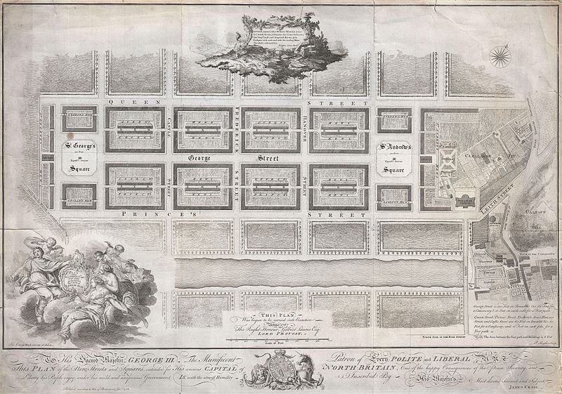
English: Drafted for the city planning committee in 1768 by James Craig, this is the definitive plan of Edinburgh, Scotland’s New Town. Oriented to the North, this plan details the streets of Edinburgh north of the Loch Nor (today the Prince’s Street Gardens) between St. George’s Square (modern day Charlotte Square) and St. Andrews Square. A dedication to King George the III illustrates the lower part of the map. An elaborate title cartouche decorates the lower left hand quadrant. Thompson’s poem appears in a secondary cartouche at the top center. In 1766 the City Fathers of Edinburgh lead by Lord Provost George Drummond instituted a plan to extend the city’s border to encompass the field’s north of the Nor Loch. The plan, intended to modernize the city and ease the crowded conditions of the old Royal Burgh, was turned into a competition. James Craig, an Edinburgh native, having around this time just completed his apprenticeship as a mason, found the he had a fine hand for drafting. Inspired by his uncle James Thomson’s well known poem Liberty , August, around, what Public Works I see, Lo’ stately Streets, lo’ Squares that Court the breeze, See’ long Canals, and deepened Rivers join Eash part with each, and with the circling Main The whole enlivened Isle… Craig submitted this plan. Though conservative in its vision, Craig’s plan won the city’s design contest and he was awarded with the “Freedom of the City” in 1767. Sadly the Lord Provost George Drummond who instituted the contest died before his dream of expanding the city was realized. It was left to his successor, the Lord Provost Gilbert Laurie, who is named on this map, to realize Craig’s plan. Today the streets are laid out much as Craig envisioned them with broad east –west avenues separating housing blocks bisected by smaller mews. Drawn by James Craig and engraved by P. Begbie in 1768. When this plan was printed in 1768, only 500 were issued. With such a small printing run as an independently issued map, we can safely assume that very few examples, other than the one you see here, have survived to this day. Only one recorded example of this map has appeared at auction in the last 30 years. Dated and copyrighted “Published according to Act of Parliament, Jan. 1st, 1768. |
|||||
| Kuupäev | 1768 (dated) | |||||
| Mõõtmed | kõrgus: 18 tolli (45,7 cm); laius: 26 tolli (66 cm) | |||||
| Inventarinumber |
Geographicus link: Edinburgh-craig-1768 |
|||||
| Allikas/Fotograaf |
|
|||||
| Luba (Faili edasikasutus) |
|
|||||
Faili ajalugu
Klõpsa kuupäeva ja kellaaega, et näha sel ajahetkel kasutusel olnud failiversiooni.
| Kuupäev/kellaaeg | Pisipilt | Mõõtmed | Kasutaja | Kommentaar | |
|---|---|---|---|---|---|
| viimane | 23. märts 2011, kell 00:16 | | 5000 × 3508 (6,08 MB) | BotMultichillT | {{subst:User:Multichill/Geographicus |link=http://www.geographicus.com/P/AntiqueMap/Edinburgh-craig-1768 |product_name=1768 James Craig Map of New Town, Edinburgh, Scotland (First Plan of New Town) |map_title=Plan of the New Streets and Squares intended |
Faili kasutus
Seda faili kasutab järgmine lehekülg:
Globaalne failikasutus
Järgmised muud vikid kasutavad seda faili:
- Faili kasutus vikis de.wikipedia.org
- Faili kasutus vikis en.wikipedia.org
- Faili kasutus vikis fr.wikipedia.org
- Faili kasutus vikis it.wikivoyage.org
- Faili kasutus vikis pt.wikipedia.org
_-_Geographicus_-_Edinburgh-craig-1768.jpg)