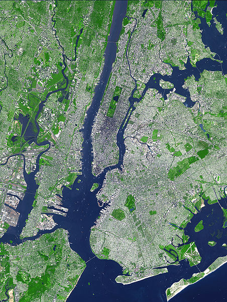
Fail:Aster newyorkcity lrg.jpg

Selle eelvaate suurus: 452 × 600 pikslit. Teised eraldusvõimed: 181 × 240 pikslit | 361 × 480 pikslit | 578 × 768 pikslit | 771 × 1024 pikslit | 1964 × 2607 pikslit.
Algfail (1964 × 2607 pikslit, faili suurus: 3,31 MB, MIME tüüp: image/jpeg)
Faili ajalugu
Klõpsa kuupäeva ja kellaaega, et näha sel ajahetkel kasutusel olnud failiversiooni.
| Kuupäev/kellaaeg | Pisipilt | Mõõtmed | Kasutaja | Kommentaar | |
|---|---|---|---|---|---|
| viimane | 8. august 2007, kell 21:54 |  | 1964 × 2607 (3,31 MB) | HenrikRomby | {{Information |Description=This false-color satellite image shows Greater New York City. The Island of Manhattan juts southward from top center, bordered by the Hudson River to the west and the East River to the east (north is straight up in this scene.) |
Faili kasutus
Seda faili kasutab järgmine lehekülg:
Globaalne failikasutus
Järgmised muud vikid kasutavad seda faili:
- Faili kasutus vikis af.wikipedia.org
- Faili kasutus vikis ar.wikipedia.org
- Faili kasutus vikis ast.wikipedia.org
- Faili kasutus vikis bn.wikipedia.org
- Faili kasutus vikis ca.wikipedia.org
- Faili kasutus vikis da.wikipedia.org
- Faili kasutus vikis de.wikipedia.org
- Faili kasutus vikis el.wikipedia.org
- Faili kasutus vikis en.wikipedia.org
- Topography
- Hudson County, New Jersey
- User:TimAlderson/Userboxes
- Hudson Waterfront
- List of bridges, tunnels, and cuts in Hudson County, New Jersey
- User:NYCRuss/Sandbox/New York City
- Trees of New York City
- Talk:Trees of New York City
- Wikipedia:WikiProject New York City/Environment Task Force
- Wikipedia:WikiProject New York City/400 Task Force
- Faili kasutus vikis en.wikibooks.org
- Faili kasutus vikis eo.wikipedia.org
- Faili kasutus vikis es.wikipedia.org
- Faili kasutus vikis fi.wikipedia.org
- Faili kasutus vikis fr.wikipedia.org
- Faili kasutus vikis fr.wikinews.org
- Faili kasutus vikis gl.wikipedia.org
- Faili kasutus vikis he.wikipedia.org
- Faili kasutus vikis hr.wikipedia.org
- Faili kasutus vikis hu.wikipedia.org
- Faili kasutus vikis hy.wikipedia.org
- Faili kasutus vikis id.wikipedia.org
- Faili kasutus vikis it.wikipedia.org
- Faili kasutus vikis ja.wikipedia.org
Vaata selle faili globaalset kasutust.


