
Fail:Trafalgar 1200hr.gif
Selle eelvaate suurus: 635 × 600 pikslit. Teised eraldusvõimed: 254 × 240 pikslit | 508 × 480 pikslit | 900 × 850 pikslit.
Algfail (900 × 850 pikslit, faili suurus: 30 KB, MIME tüüp: image/gif)
| See fail ja sellest kastist allapoole jääv kirjeldus pärinevad kesksest failivaramust Wikimedia Commons. | Faili lehekülg Commonsis |

|
This file has been superseded by Trafalgar 1200hr.svg. It is recommended to use the other file. Please note that deleting superseded images requires consent. Reason to use the other file: "The new file is SVG, and has less spelling mistakes"
|

|
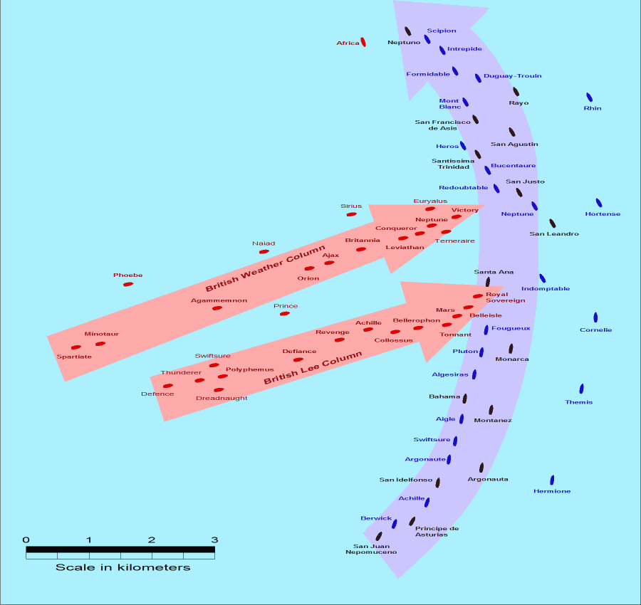
- Description: This map of the Battle of Trafalgar shows the approximate position of the two fleets at 1200 hours during the battle as the Royal Sovereign was breaking into the Franco-Spanish line. North is to the top, and Cape Trafalgar is 10 miles to the northeast.
- Size: 900 × 850 pixels.
- Source: This drawing is based on an illustration in issue number 84 of the Strategy & Tactics magazine The map was made by RJHall using the Campaign Cartographer drawing program, and the image was reduced in size 50% in Paint Shop Pro. Ship icons are not to scale.
See fail kuulub Creative Commonsi üldise litsentsi "Autorile viitamine + jagamine samadel tingimustel 2.5" alla.
- Tohid:
- jagada – teost kopeerida, levitada ja edastada
- kohandada – valmistada muudetud teoseid
- Järgmistel tingimustel:
- omistamine – Pead materjali sobival viisil autorile omistama, tooma ära litsentsi lingi ja märkima ära, kas on tehtud muudatusi. Sobib, kui teed seda mõistlikul viisil, kuid seejuures ei tohi jääda muljet, et litsentsiandja tõstab esile sind või seda, et sina materjali kasutad.
- sarnaselt jagamine – Kui töötled, kujundad ümber või arendad materjali edasi, siis pead oma töö levitamiseks kasutama sama litsentsi, mille all on algupärand, või ühilduvat litsentsi.
Faili ajalugu
Klõpsa kuupäeva ja kellaaega, et näha sel ajahetkel kasutusel olnud failiversiooni.
| Kuupäev/kellaaeg | Pisipilt | Mõõtmed | Kasutaja | Kommentaar | |
|---|---|---|---|---|---|
| viimane | 28. juuli 2005, kell 17:30 | | 900 × 850 (30 KB) | RJHall | Battle of Trafalgar situation at 1200hr, 21 October 1805. |
Faili kasutus
Seda faili ei kasuta ükski lehekülg.
Globaalne failikasutus
Järgmised muud vikid kasutavad seda faili:
- Faili kasutus vikis fr.wikipedia.org
- Faili kasutus vikis ja.wikipedia.org