
Fail:Submarine cables.png

Selle eelvaate suurus: 641 × 600 pikslit. Teised eraldusvõimed: 257 × 240 pikslit | 513 × 480 pikslit | 1021 × 955 pikslit.
Algfail (1021 × 955 pikslit, faili suurus: 81 KB, MIME tüüp: image/png)
| See fail ja sellest kastist allapoole jääv kirjeldus pärinevad kesksest failivaramust Wikimedia Commons. | Faili lehekülg Commonsis |
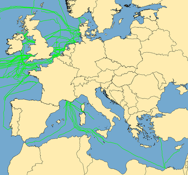
| Kirjeldus | Map with examples of submarine communications cables. Some of the cables represented were incomplete in the mapping stage; they do not go to "nowhere", they are merely incomplete when this image was captured. | ||
| Kuupäev | (UTC) | ||
| Allikas | Data taken from public sources. Created using MapInfo Professional v8.5 and various mapping resources. | ||
| Autor | Rarelibra | ||
| Luba (Faili edasikasutus) |
|
Faili ajalugu
Klõpsa kuupäeva ja kellaaega, et näha sel ajahetkel kasutusel olnud failiversiooni.
| Kuupäev/kellaaeg | Pisipilt | Mõõtmed | Kasutaja | Kommentaar | |
|---|---|---|---|---|---|
| viimane | 7. oktoober 2019, kell 13:53 | | 1021 × 955 (81 KB) | Bjh21 | Reverted to version as of 19:07, 13 August 2007 (UTC): Waldyrious and User:Μυρμηγκάκι have already reverted this version, which is an objection under COM:OVERWRITE. Also the world map is already available at File:World map of submarine cables.png. |
| 7. oktoober 2019, kell 06:27 |  | 1601 × 1025 (74 KB) | Rarelibra | Reverted to version as of 07:57, 2 October 2008 (UTC) | |
| 21. detsember 2008, kell 16:09 |  | 1021 × 955 (81 KB) | Waldyrious | Reverted to original version. Other versions will be uploaded separately. | |
| 2. oktoober 2008, kell 15:55 |  | 1025 × 614 (16 KB) | Rarelibra | Reverted to version as of 22:13, 1 February 2008 | |
| 2. oktoober 2008, kell 10:57 |  | 1601 × 1025 (74 KB) | Μυρμηγκάκι | Reverted to version as of 23:22, 22 August 2007 | |
| 2. veebruar 2008, kell 01:13 |  | 1025 × 614 (16 KB) | Rarelibra | Updated example of a submarine cable in the North Sea. The blue line depicts the ACTUAL location of the submarine cable, taken from GPS coordinates of the cable. The red line depicts the REPRESENTATIVE location of the submarine cable. | |
| 23. august 2007, kell 02:22 |  | 1601 × 1025 (74 KB) | Rarelibra | Updated map with cables around the world. | |
| 13. august 2007, kell 22:07 |  | 1021 × 955 (81 KB) | Rarelibra | Map with examples of submarine communications cables in Europe (Mediterranean Sea, English Channel, and North Sea). Data taken from public sources for fishermen and is therefore not restricted in any sense. Created by ~~~~ for public domain use, using Map |
Faili kasutus
Seda faili ei kasuta ükski lehekülg.
Globaalne failikasutus
Järgmised muud vikid kasutavad seda faili:
- Faili kasutus vikis da.wikipedia.org
- Faili kasutus vikis de.wikipedia.org
- Faili kasutus vikis en.wikipedia.org