
Fail:Chennai.png
Sellest suuremat pilti pole.
Chennai.png (219 × 164 pikslit, faili suurus: 13 KB, MIME tüüp: image/png)
| See fail ja sellest kastist allapoole jääv kirjeldus pärinevad kesksest failivaramust Wikimedia Commons. | Faili lehekülg Commonsis |
| Kirjeldus |
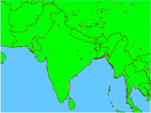
English: This is an incorrect representation of the Republic of India. For a proper geographically correct version of the Republic of India click here: http://www.worldatlas.com/webimage/countrys/asia/lgcolor/incolor.htm This map is an objective illustration showing even the "disputed" region of Kashmir which forms an integral part of India. This map was generated using all open-source software on an open-source unix operating system. The map itself and the marking of the co-ordinates were done using GMT software, and conversion to png format was done using ImageMagick. Please notice this is different form using graphics arts software tools to create maps or other pictures. In fact, this map was created by issuing only 3 command lines from a unix shell, without even using any GUI -- and GUI was used only to view the final picture before uploading it. GMT is a geographic and cartographic set of tools, with extensive capabilities and options. |
| Kuupäev | |
| Allikas | Üleslaadija oma töö |
| Autor | Teadmata |

|
Luba on antud selle dokumendi kopeerimiseks, avaldamiseks ja/või muutmiseks GNU Vaba Dokumentatsiooni Litsentsi versiooni 1.2 või hilisema Vaba Tarkvara Fondi avaldatud versiooni tingimuste alusel; muutumatute osadeta, esikaane tekstideta ja tagakaane tekstideta. Sellest loast on lisatud koopia leheküljel pealkirjaga "GNU Free Documentation License". |
| See fail kuulub jurisdiktsiooniga sidumata Creative Commonsi litsentsi "Autorile viitamine + jagamine samadel tingimustel 3.0" alla. | ||
| ||
| See litsentsimärgis lisati sellele failile GFDL-i litsentsimisuuenduse raames. |
Faili ajalugu
Klõpsa kuupäeva ja kellaaega, et näha sel ajahetkel kasutusel olnud failiversiooni.
| Kuupäev/kellaaeg | Pisipilt | Mõõtmed | Kasutaja | Kommentaar | |
|---|---|---|---|---|---|
| viimane | 6. jaanuar 2005, kell 16:51 | | 219 × 164 (13 KB) | Sebastian Wallroth | This is an incorrect representation of the Republic of India. For a proper geographically correct version of the Republic of India click here: http://www.worldatlas.com/webimage/countrys/asia/lgcolor/incolor.htm This map is an objective illustration showi |
Faili kasutus
Seda faili ei kasuta ükski lehekülg.
Globaalne failikasutus
Järgmised muud vikid kasutavad seda faili: