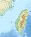
Fail:Taiwan relief location map.jpg

Selle lehekülje sisule puudub teiste keelte tugi.
Klõps ikoonil viib faili leheküljele Wikimedia Commonsis.
Allikas: Vikipeedia

Algfail(1016 × 1222 pikslit, faili suurus: 101 KB, MIME tüüp: image/jpeg)

Warning sign This file requires updating because: The earlier forms of this map did not extend a dotted-line around Dongyin, Lienchiang (Tungyin). The northern edge of this map ought to be moved up a little bit (in latitude) so that a dotted line encompassing Dongyin (Tungyin) can be clearly drawn and so that we can see a few of the islands north of Lienchiang County in Haidao Township, PRC. Example of a better map from The Economist: [1]. In doing so, you could add a timestamp to the file.
Please notify the uploader with {{subst:update-note|1=File:Taiwan relief location map.jpg|2=The earlier forms of this map did not extend a dotted-line around Dongyin, Lienchiang (Tungyin). The northern edge of this map ought to be moved up a little bit (in latitude) so that a dotted line encompassing Dongyin (Tungyin) can be clearly drawn and so that we can see a few of the islands north of Lienchiang County in Haidao Township, PRC. Example of a better map from The Economist: [2].}} ~~~~

Lühikirjeldus

Kirjeldus
English: Relief location map of Taiwan.
  • Projection: Equirectangular projection, strechted by 110.0%.
  • Geographic limits of the map:
  • N: 26.4° N
  • S: 21.7° N
  • W: 118.0° E
  • E: 122.3° E
  • GMT projection: -JX17.204266666666665cd/20.68512992248063cd
  • GMT region: -R118.0/21.7/122.3/26.4r
  • GMT region for grdcut: -R118.0/21.7/122.3/26.4r
  • Relief: SRTM30plus.
  • Made with Natural Earth. Free vector and raster map data @ naturalearthdata.com.
Kuupäev
Allikas Üleslaadija oma töö
Autor Uwe Dedering

Litsents

Autoriõiguse omanikuna avaldan selle teose järgmiste litsentside all:
w:et:Creative Commons
omistamine sarnaselt jagamine
See fail kuulub Creative Commonsi jurisdiktsiooniga sidumata litsentsi "Autorile viitamine + jagamine samadel tingimustel 3.0" ning üldise litsentsi "Autorile viitamine + jagamine samadel tingimustel" versioonide 2.5, 2.0 ja 1.0 alla.
Tohid:
  • jagada – teost kopeerida, levitada ja edastada
  • kohandada – valmistada muudetud teoseid
Järgmistel tingimustel:
  • omistamine – Pead materjali sobival viisil autorile omistama, tooma ära litsentsi lingi ja märkima ära, kas on tehtud muudatusi. Sobib, kui teed seda mõistlikul viisil, kuid seejuures ei tohi jääda muljet, et litsentsiandja tõstab esile sind või seda, et sina materjali kasutad.
  • sarnaselt jagamine – Kui töötled, kujundad ümber või arendad materjali edasi, siis pead oma töö levitamiseks kasutama sama litsentsi, mille all on algupärand, või ühilduvat litsentsi.
GNU head Luba on antud selle dokumendi kopeerimiseks, avaldamiseks ja/või muutmiseks GNU Vaba Dokumentatsiooni Litsentsi versiooni 1.2 või hilisema Vaba Tarkvara Fondi avaldatud versiooni tingimuste alusel; muutumatute osadeta, esikaane tekstideta ja tagakaane tekstideta. Sellest loast on lisatud koopia leheküljel pealkirjaga "GNU Free Documentation License".
Sa võid valida endale sobiva litsentsi.

Pealdised

Lisa üherealine seletus sellest, mida fail esitab

Selles failis kujutatud üksused

kujutab

28. detsember 2010

media type inglise

image/jpeg

Faili ajalugu

Klõpsa kuupäeva ja kellaaega, et näha sel ajahetkel kasutusel olnud failiversiooni.

Kuupäev/kellaaegPisipiltMõõtmedKasutajaKommentaar
viimane19. september 2019, kell 17:01Pisipilt versioonist seisuga 19. september 2019, kell 17:011016 × 1222 (101 KB)Geographyinitiativetemporary fix: extending the boundary out around Dongyin Township (as in China Fujian2 location map.svg and as in File:Nationalist China - administrative divisons. LOC 2007633622.jpg)
3. august 2019, kell 20:09Pisipilt versioonist seisuga 3. august 2019, kell 20:091016 × 1222 (537 KB)NordNordWestborder corrections
3. august 2019, kell 04:51Pisipilt versioonist seisuga 3. august 2019, kell 04:511016 × 1222 (96 KB)GeographyinitiativeProposed removal of three dashes (markers of the approximate PRC/ROC maritime boundary) which seemed to put Dadan Island, Erdan Island and Binlang Islet (檳榔嶼) outside the territory of Kinmen County, Taiwan/ROC. This is not the optimal form of the map, but is merely a quick removal of incorrect information. In the optimal situation, the line needs to be redrawn in the correct location, but I don't have the technical skill to produce such a map. (Basis: [http://ws.mac.gov.tw/001/Upload/OldFile/...
3. august 2019, kell 03:30Pisipilt versioonist seisuga 3. august 2019, kell 03:301016 × 1222 (96 KB)GeographyinitiativeProposed removal of two dashes (markers of the approximate PRC/ROC maritime boundary) which seemed to put {{w|Dadan Island}} and {{w|Erdan Island}} outside the territory of {{w|Kinmen County}}, Taiwan/ROC.
28. detsember 2010, kell 20:22Pisipilt versioonist seisuga 28. detsember 2010, kell 20:221016 × 1222 (452 KB)Uwe Dedering{{Information |Description={{en|1=Relief location map of Taiwan. * Projection: Equirectangular projection, strechted by 110.0%. * Geographic limits of the map: :* N: 26.4° N :* S: 21.7° N :* W: 118.0° E :* E: 122.3° E * GMT projection: -JX17.204266666

Seda faili kasutavad järgmised 2 lehekülge:

Globaalne failikasutus

Järgmised muud vikid kasutavad seda faili:

Vaata selle faili globaalset kasutust.

Metaandmed