
Fail:Habsburg Map 1547.jpg
Algfail (1654 × 1029 pikslit, faili suurus: 534 KB, MIME tüüp: image/jpeg)
| See fail ja sellest kastist allapoole jääv kirjeldus pärinevad kesksest failivaramust Wikimedia Commons. | Faili lehekülg Commonsis |
Lühikirjeldus
| Kirjeldus |
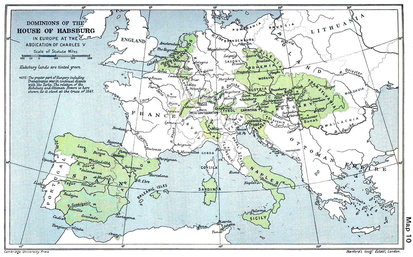
English: A map of the dominion of the Habsburgs following the Battle of Mühlberg (1547) |
| Kuupäev | |
| Allikas |
The Cambridge Modern History Atlas, edited by Sir Adolphus William Ward, G.W. Prothero, Sir Stanley Mordaunt Leathes, and E.A. Benians. Cambridge University Press: London, 1912. Editors were Sir Adolphus William Ward (†1924), G.W. Prothero (†1922), and Sir Stanley Mordaunt Leathes (†1938). Individual authors of works making up the atlas are not identified, nor are the likely to be, after reasonable research. |
| Autor | edited by Sir Adolphus William Ward, G.W. Prothero, Sir Stanley Mordaunt Leathes |
| Teised versioonid |
|

Litsents
See fail on Ühendriikides avalikus omandis, sest see avaldati (või registreeriti USA autoriõiguse ametis) enne 1. jaanuari 1929.
Selleks et avaliku omandi teost saaks Commonsis hoida, peab selle autoriõiguse kehtivus olema lõppenud nii Ühendriikides kui ka päritoluriigis. Kui see ole Ühendriikide teos, siis peab selle juures olema ka autoriõiguse märgis, mis nätab, milline on teose autoriõiguslik staatus päritoluriigis.
|
This UK artistic or literary work, of which the author is unknown and cannot be ascertained by reasonable enquiry, is in the public domain because it is one of the following:
|
 |
Faili ajalugu
Klõpsa kuupäeva ja kellaaega, et näha sel ajahetkel kasutusel olnud failiversiooni.
| Kuupäev/kellaaeg | Pisipilt | Mõõtmed | Kasutaja | Kommentaar | |
|---|---|---|---|---|---|
| viimane | 29. märts 2018, kell 12:20 | | 1654 × 1029 (534 KB) | Trecătorul răcit | Little add: borders of the time |
| 3. september 2015, kell 14:01 |  | 1654 × 1029 (518 KB) | Kurzon | Reverted to version as of 17:22, 9 August 2010 | |
| 3. september 2015, kell 14:01 |  | 1654 × 1029 (518 KB) | Kurzon | Reverted to version as of 17:22, 9 August 2010 | |
| 30. juuni 2013, kell 00:33 |  | 1654 × 1029 (546 KB) | CSvBibra | add more contrast per request by another user | |
| 9. august 2010, kell 20:22 |  | 1654 × 1029 (518 KB) | CSvBibra | Previously put cleaned up version in new file with "b" after name. Now updating original file with "b" version. Both files uses throughout Wikipedias | |
| 28. august 2008, kell 12:07 |  | 1654 × 1029 (649 KB) | F l a n k e r | Wrap, shadows and minor improvements | |
| 28. juuni 2005, kell 17:42 |  | 1654 × 1029 (421 KB) | Rythin~commonswiki | A map of the dominion of the Habsburgs following the Battle of Mühlberg (1547). Taken from ''The Cambridge Modern History Atlas,'' edited by Sir Adolphus William Ward, G.W. Prothero, Sir Stanley Mordaunt Leathes, and E.A. Benians. Cambridge University Pr |
Faili kasutus
Seda faili kasutavad järgmised 2 lehekülge:
Globaalne failikasutus
Järgmised muud vikid kasutavad seda faili:
- Faili kasutus vikis af.wikipedia.org
- Faili kasutus vikis an.wikipedia.org
- Faili kasutus vikis ar.wikipedia.org
- Faili kasutus vikis arz.wikipedia.org
- Faili kasutus vikis ast.wikipedia.org
- Faili kasutus vikis azb.wikipedia.org
- Faili kasutus vikis ba.wikipedia.org
- Faili kasutus vikis be.wikipedia.org
- Faili kasutus vikis bg.wikipedia.org
- Faili kasutus vikis br.wikipedia.org
- Faili kasutus vikis bs.wikipedia.org
- Faili kasutus vikis ca.wikipedia.org
- Faili kasutus vikis cs.wikipedia.org
- Faili kasutus vikis da.wikipedia.org
- Faili kasutus vikis de.wikipedia.org
- Faili kasutus vikis el.wikipedia.org
Vaata selle faili globaalset kasutust.