
Fail:Un-syria.png
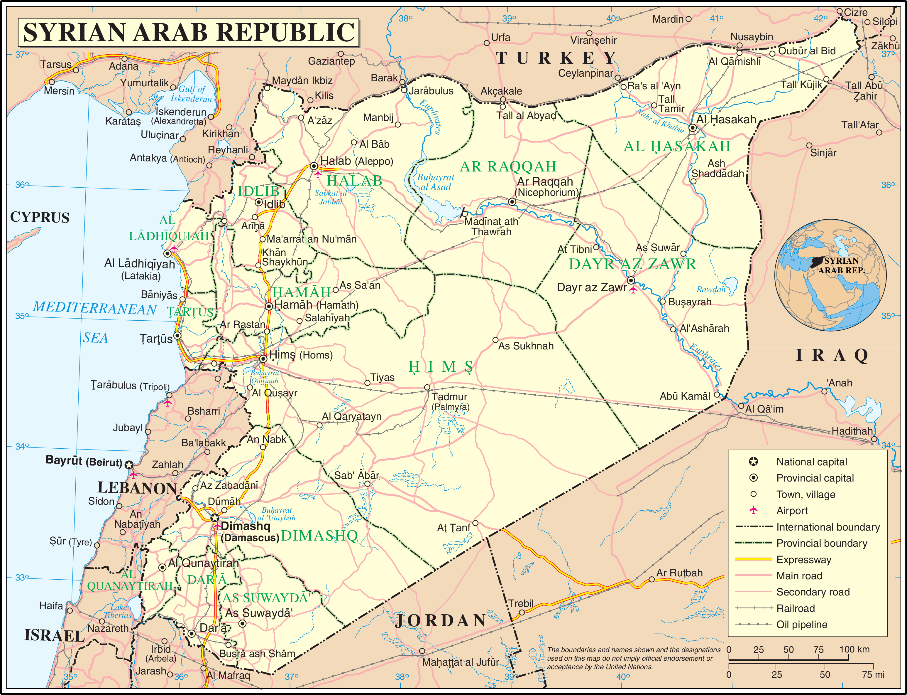
Algfail (3092 × 2367 pikslit, faili suurus: 2,21 MB, MIME tüüp: image/png)
| See fail ja sellest kastist allapoole jääv kirjeldus pärinevad kesksest failivaramust Wikimedia Commons. | Faili lehekülg Commonsis |
| This image is a map derived from a United Nations map.
Unless stated otherwise, UN maps are to be considered in the public domain. This applies worldwide. UN maps are, in principle, open source material and you can use them in your work or for making your own map. UN requests however that you delete the UN name, logo and reference number upon any modification to the map. Content of your map will be your responsibility. You can state in your publication, if you wish, something like: based on UN map … (map name, map number, revision number and date). See: Geospatial Information Section. And: Geospatial, location data for a better world. |
 |
Faili ajalugu
Klõpsa kuupäeva ja kellaaega, et näha sel ajahetkel kasutusel olnud failiversiooni.
| Kuupäev/kellaaeg | Pisipilt | Mõõtmed | Kasutaja | Kommentaar | |
|---|---|---|---|---|---|
| viimane | 24. oktoober 2007, kell 05:20 | | 3092 × 2367 (2,21 MB) | Jeroen | {{UN map}} Category:Maps of Syria |
Faili kasutus
Seda faili ei kasuta ükski lehekülg.
Globaalne failikasutus
Järgmised muud vikid kasutavad seda faili:
- Faili kasutus vikis ar.wikipedia.org
- Faili kasutus vikis ca.wikipedia.org
- Faili kasutus vikis ckb.wikipedia.org
- Faili kasutus vikis en.wikipedia.org
- Faili kasutus vikis fa.wikipedia.org
- Faili kasutus vikis fi.wikipedia.org
- Faili kasutus vikis fr.wikipedia.org
- Faili kasutus vikis gom.wikipedia.org
- Faili kasutus vikis id.wikipedia.org
- Faili kasutus vikis ja.wikipedia.org
- Faili kasutus vikis mzn.wikipedia.org
- Faili kasutus vikis nl.wikipedia.org
- Faili kasutus vikis pl.wiktionary.org
- Faili kasutus vikis ru.wikipedia.org
- Faili kasutus vikis ru.wikinews.org
- Faili kasutus vikis tg.wikipedia.org
Vaata selle faili globaalset kasutust.