
Fail:Royal-geographical-society geographical-journal 1914 macquarie-island-antarctica 1381 2000 600.jpg

Selle eelvaate suurus: 429 × 599 pikslit. Teised eraldusvõimed: 172 × 240 pikslit | 344 × 480 pikslit | 550 × 768 pikslit | 733 × 1024 pikslit | 2000 × 2792 pikslit.
Algfail (2000 × 2792 pikslit, faili suurus: 610 KB, MIME tüüp: image/jpeg)
| See fail ja sellest kastist allapoole jääv kirjeldus pärinevad kesksest failivaramust Wikimedia Commons. | Faili lehekülg Commonsis |
Lühikirjeldus
| Kirjeldus |
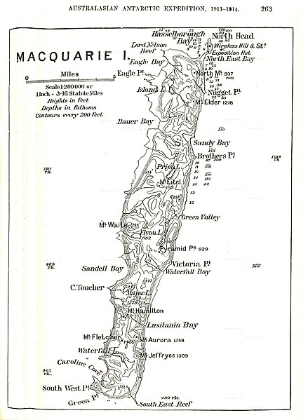
English: old map of Macquarie Island, Tasmania, Australia |
| Kuupäev | |
| Allikas | http://www.hipkiss.org/data/maps/royal-geographical-society_geographical-journal_1914_macquarie-island-antarctica_1381_2000_600.jpg |
| Autor | Teadmata |
Litsents
See fail on Ühendriikides avalikus omandis, sest see avaldati (või registreeriti USA autoriõiguse ametis) enne 1. jaanuari 1929.
|
This image or other work is of Australian origin and is now in the public domain because its term of copyright has expired. According to the Australian Copyright Council (ACC), ACC Information Sheet G023v19 (Duration of copyright) (January 2019).1
When using this template, please provide information of where the image was first published and who created it. |
 | |||||||||||||||||||
First published in Douglas Mawson's Home of the Blizzard 1914
Faili ajalugu
Klõpsa kuupäeva ja kellaaega, et näha sel ajahetkel kasutusel olnud failiversiooni.
| Kuupäev/kellaaeg | Pisipilt | Mõõtmed | Kasutaja | Kommentaar | |
|---|---|---|---|---|---|
| viimane | 16. november 2020, kell 22:40 | | 2000 × 2792 (610 KB) | CSvBibra | sharpen, reduce distortion, contrast |
| 20. september 2011, kell 14:10 |  | 1381 × 2000 (293 KB) | Ratzer | {{Information |Description ={{en|1=old map of Macquarie Island, Tasmania, Australia}} |Source =http://www.hipkiss.org/data/maps/royal-geographical-society_geographical-journal_1914_macquarie-island-antarctica_1381_2000_600.jpg |Author = |
Faili kasutus
Seda faili kasutab järgmine lehekülg:
Globaalne failikasutus
Järgmised muud vikid kasutavad seda faili:
- Faili kasutus vikis de.wikipedia.org
- Faili kasutus vikis fa.wikipedia.org
- Faili kasutus vikis frr.wikipedia.org
- Faili kasutus vikis fr.wikipedia.org
- Faili kasutus vikis hu.wikipedia.org
- Faili kasutus vikis ja.wikipedia.org
- Faili kasutus vikis mrj.wikipedia.org
- Faili kasutus vikis nn.wikipedia.org
- Faili kasutus vikis pt.wikipedia.org
- Faili kasutus vikis ru.wikipedia.org
- Faili kasutus vikis simple.wikipedia.org
- Faili kasutus vikis tr.wikipedia.org
- Faili kasutus vikis vi.wikipedia.org