
Fail:Ophir Town Hall.jpg

Selle eelvaate suurus: 780 × 599 pikslit. Teised eraldusvõimed: 312 × 240 pikslit | 625 × 480 pikslit | 1000 × 768 pikslit | 1280 × 984 pikslit | 2560 × 1967 pikslit | 4659 × 3580 pikslit.
Algfail (4659 × 3580 pikslit, faili suurus: 1,81 MB, MIME tüüp: image/jpeg)
| See fail ja sellest kastist allapoole jääv kirjeldus pärinevad kesksest failivaramust Wikimedia Commons. | Faili lehekülg Commonsis |
|
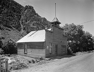
This is an image of a place or building that is listed on the National Register of Historic Places in the United States of America. Its reference number is 83003193. |
| Kaamera asukoht | | See ja teised pildid sellest paigast lehel: OpenStreetMap |
|---|
| Kirjeldus |
English: Front of the town hall in Ophir, Utah, United States. Built in 1870 and located at 43 S. Main Street, the town hall is listed on the National Register of Historic Places. |
|||||
| Kuupäev | ||||||
| Allikas | Library of Congress, Prints and Photograph Division HABS: UTAH,23-OPHIR,1-2 | |||||
| Autor | P. Kent Fairbanks | |||||
| Luba (Faili edasikasutus) |
|


|
This image is available from the United States Library of Congress's Prints and Photographs division
under the digital ID hhh.ut0098. This tag does not indicate the copyright status of the attached work. A normal copyright tag is still required. See Commons:Licensing.
|
Faili ajalugu
Klõpsa kuupäeva ja kellaaega, et näha sel ajahetkel kasutusel olnud failiversiooni.
| Kuupäev/kellaaeg | Pisipilt | Mõõtmed | Kasutaja | Kommentaar | |
|---|---|---|---|---|---|
| viimane | 23. mai 2009, kell 11:04 | | 4659 × 3580 (1,81 MB) | Cropbot | upload cropped version, operated by User:Finavon. Summary: border cropped |
| 22. mai 2009, kell 05:20 |  | 4993 × 4002 (2 MB) | Nyttend | {{Location|40|22|12|N|112|15|10|W}} {{Information |Description={{en|Front of the {{w|Ophir Town Hall|town hall}} in {{w|Ophir, Utah|Ophir}}, {{w|Utah}}, {{w|United States}}. Built in 1870 and located at 43 S. Main Street, the town hall is listed on the { |
Faili kasutus
Seda faili kasutab järgmine lehekülg:
Globaalne failikasutus
Järgmised muud vikid kasutavad seda faili:
- Faili kasutus vikis en.wikipedia.org
- Faili kasutus vikis www.wikidata.org