
Fail:Map Byzantine Empire 1076-fr.svg

Selle SVG-faili PNG-vormingus eelvaate suurus: 800 × 450 pikslit. Teised eraldusvõimed: 320 × 180 pikslit | 640 × 360 pikslit | 1024 × 576 pikslit | 1280 × 720 pikslit | 2560 × 1440 pikslit | 1963 × 1104 pikslit.
Algfail (SVG-fail, algsuurus 1963 × 1104 pikslit, faili suurus: 92 KB)
| See fail ja sellest kastist allapoole jääv kirjeldus pärinevad kesksest failivaramust Wikimedia Commons. | Faili lehekülg Commonsis |

Lühikirjeldus
| Kirjeldus |
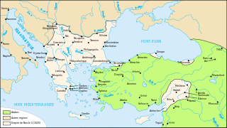
Français : Carte de l'empire byzantin en 1076 |
| Kuupäev | |
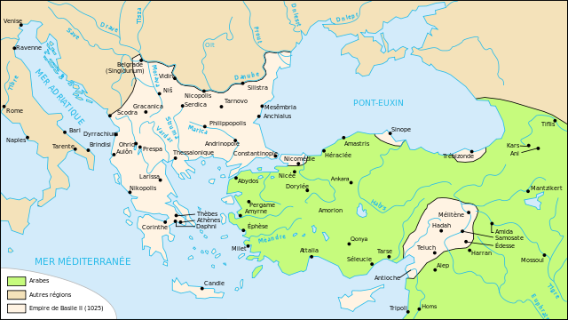
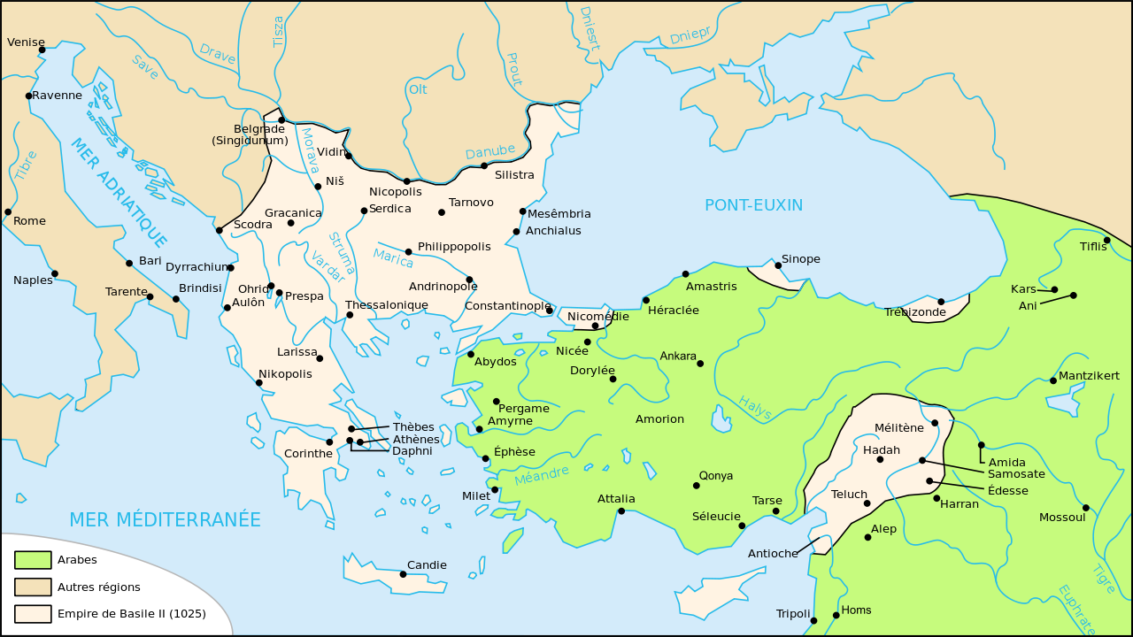
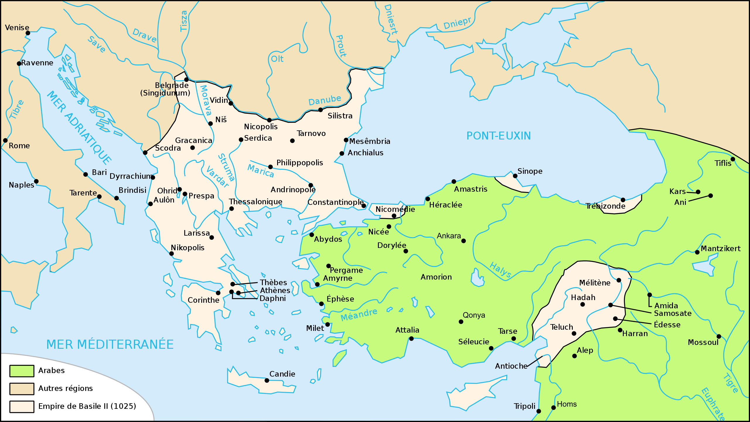
| Allikas | Üleslaadija oma töö järgmise faili põhjal: Map Byzantine Empire 1025-fr.svg |
| Autor | Odejea |
| Teised versioonid |
[]
|


Litsents
Autoriõiguse omanikuna avaldan selle teose järgmiste litsentside all:

|
Luba on antud selle dokumendi kopeerimiseks, avaldamiseks ja/või muutmiseks GNU Vaba Dokumentatsiooni Litsentsi versiooni 1.2 või hilisema Vaba Tarkvara Fondi avaldatud versiooni tingimuste alusel; muutumatute osadeta, esikaane tekstideta ja tagakaane tekstideta. Sellest loast on lisatud koopia leheküljel pealkirjaga "GNU Free Documentation License". |
See fail kuulub Creative Commonsi jurisdiktsiooniga sidumata litsentsi "Autorile viitamine + jagamine samadel tingimustel 3.0" ning üldise litsentsi "Autorile viitamine + jagamine samadel tingimustel" versioonide 2.5, 2.0 ja 1.0 alla.
- Tohid:
- jagada – teost kopeerida, levitada ja edastada
- kohandada – valmistada muudetud teoseid
- Järgmistel tingimustel:
- omistamine – Pead materjali sobival viisil autorile omistama, tooma ära litsentsi lingi ja märkima ära, kas on tehtud muudatusi. Sobib, kui teed seda mõistlikul viisil, kuid seejuures ei tohi jääda muljet, et litsentsiandja tõstab esile sind või seda, et sina materjali kasutad.
- sarnaselt jagamine – Kui töötled, kujundad ümber või arendad materjali edasi, siis pead oma töö levitamiseks kasutama sama litsentsi, mille all on algupärand, või ühilduvat litsentsi.
Sa võid valida endale sobiva litsentsi.
Faili ajalugu
Klõpsa kuupäeva ja kellaaega, et näha sel ajahetkel kasutusel olnud failiversiooni.
| Kuupäev/kellaaeg | Pisipilt | Mõõtmed | Kasutaja | Kommentaar | |
|---|---|---|---|---|---|
| viimane | 30. aprill 2012, kell 23:41 | | 1963 × 1104 (92 KB) | Spiridon Ion Cepleanu | Reverted to version as of 20:55, 12 November 2008 |
| 30. aprill 2012, kell 23:40 |  | 842 × 595 (122 KB) | Spiridon Ion Cepleanu | Rectification since all historic atlases and also John Haldon : ''Warfare, State And Society In The Byzantine World 565-1204'' (Routledge 1999) ISBN 1-85728-494-1, Maps IV et follow., & Piers Paul Read, "The Templars", London, Phoenix Press, Orion Publ... | |
| 12. november 2008, kell 23:55 |  | 1963 × 1104 (92 KB) | Odejea | oups mauvaise version | |
| 12. november 2008, kell 23:54 |  | 1963 × 1104 (93 KB) | Odejea | décalage vert | |
| 12. november 2008, kell 23:08 |  | 1963 × 1104 (93 KB) | Odejea | contour des domaines de Philaretos Brakhamios | |
| 12. november 2008, kell 23:00 |  | 1963 × 1104 (86 KB) | Odejea | {{Information |Description={{fr|1=Carte de l'empire byzantin en 1076}} |Source=travail personnel à partir de Image:Map Byzantine Empire 1025-fr.svg |Author=Odejea |Date=12 novembre 2008 |Permission= |other_versions= }} <!--{{ImageUp |
Faili kasutus
Seda faili kasutab järgmine lehekülg:
Globaalne failikasutus
Järgmised muud vikid kasutavad seda faili:
- Faili kasutus vikis pl.wikipedia.org
- Faili kasutus vikis ru.wikipedia.org
- Faili kasutus vikis uk.wikipedia.org