
Fail:LondonBrent.png
Sellest suuremat pilti pole.
LondonBrent.png (200 × 155 pikslit, faili suurus: 23 KB, MIME tüüp: image/png)
| See fail ja sellest kastist allapoole jääv kirjeldus pärinevad kesksest failivaramust Wikimedia Commons. | Faili lehekülg Commonsis |
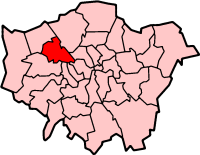
London Borough of Brent
Map drawn by en:User:Morwen

|
Luba on antud selle dokumendi kopeerimiseks, avaldamiseks ja/või muutmiseks GNU Vaba Dokumentatsiooni Litsentsi versiooni 1.2 või hilisema Vaba Tarkvara Fondi avaldatud versiooni tingimuste alusel; muutumatute osadeta, esikaane tekstideta ja tagakaane tekstideta. Sellest loast on lisatud koopia leheküljel pealkirjaga "GNU Free Documentation License". |
| See fail kuulub jurisdiktsiooniga sidumata Creative Commonsi litsentsi "Autorile viitamine + jagamine samadel tingimustel 3.0" alla. | ||
| ||
| See litsentsimärgis lisati sellele failile GFDL-i litsentsimisuuenduse raames. |
Faili ajalugu
Klõpsa kuupäeva ja kellaaega, et näha sel ajahetkel kasutusel olnud failiversiooni.
| Kuupäev/kellaaeg | Pisipilt | Mõõtmed | Kasutaja | Kommentaar | |
|---|---|---|---|---|---|
| viimane | 9. aprill 2005, kell 12:56 | | 200 × 155 (23 KB) | Voyager | London Borough of Brent Map drawn by en:User:Morwen {{GFDL}} Category:Maps of London |
Faili kasutus
Seda faili ei kasuta ükski lehekülg.
Globaalne failikasutus
Järgmised muud vikid kasutavad seda faili:
- Faili kasutus vikis ar.wikipedia.org
- Faili kasutus vikis da.wikipedia.org
- Faili kasutus vikis en.wikipedia.org
- Alperton
- Brondesbury
- Cricklewood
- Harlesden
- Kensal Green
- Kenton, London
- Kilburn, London
- Kingsbury, London
- Neasden
- London Borough of Brent
- Wembley
- Willesden
- Dollis Hill
- Dollis Hill tube station
- Burnt Oak
- Wembley Park
- Colindale
- Queen's Park, London
- Paddock (war rooms)
- Parks and open spaces in the London Borough of Brent
- North Wembley
- Park Royal
- Sudbury, London
- Stonebridge, London
- Mapesbury
- Queensbury, London
- Brondesbury Park
- Preston, London
- Brent Park, Neasden
- Roe Green Park
- Template:LB Brent
- Tokyngton
- Fryent Country Park
- Category:London Borough of Brent
- List of public art in the London Borough of Brent
- St Raphael's Estate
- Church End, Brent
- Chalkhill Estate
- List of people from the London Borough of Brent
- The Library at Willesden Green
- Grade I and II* listed buildings in the London Borough of Brent
- Brent Civic Centre
- Wikipedia:WikiProject Navigation templates/Country subdivisions/United Kingdom/England
- London Designer Outlet
- User:Victor P./sandbox3
- Faili kasutus vikis fr.wikipedia.org
Vaata selle faili globaalset kasutust.