
Fail:EU Balkan enlargement.svg

Selle SVG-faili PNG-vormingus eelvaate suurus: 680 × 520 pikslit. Teised eraldusvõimed: 314 × 240 pikslit | 628 × 480 pikslit | 1004 × 768 pikslit | 1280 × 979 pikslit | 2560 × 1958 pikslit.
Algfail (SVG-fail, algsuurus 680 × 520 pikslit, faili suurus: 601 KB)
| See fail ja sellest kastist allapoole jääv kirjeldus pärinevad kesksest failivaramust Wikimedia Commons. | Faili lehekülg Commonsis |
Lühikirjeldus
| Kirjeldus |
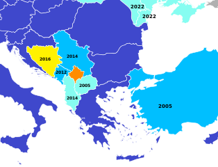
English (en): A map of the European Union potential candidate states in the Balkans, with the date of the latest step in the process.
Member states Candidates negotiating membership Candidates Potential candidates which have submitted a membership application Potential candidates which have not submitted a membership application
español (es): Estado actual de las candidaturas para la adhesión a la Unión Europea
Estados miembros. Candidatos oficiales negociando las condiciones de adhesión. Candidatos oficiales que aún no han comenzado a negociar. Candidatos potenciales que han presentado la candidatura. Candidatos potenciales que no han presentado candidatura.
|
| Kuupäev | (UTC) |
| Allikas | No machine-readable source is provided. Blank map of Europe.svg is assumed. |
| Autor |
|
| See on töödeldud pilt, mis tähendab, et selle pildi tuletamiseks on algupärast pilti digitaalselt muudetud. Muudatused: crop and colour. Algupärand: Blank map of Europe.svg. Muutnud Danlaycock.
|
Litsents
Autoriõiguse omanikuna avaldan selle teose järgmise litsentsi all:
See fail kuulub Creative Commonsi üldise litsentsi "Autorile viitamine + jagamine samadel tingimustel 2.5" alla.
- Tohid:
- jagada – teost kopeerida, levitada ja edastada
- kohandada – valmistada muudetud teoseid
- Järgmistel tingimustel:
- omistamine – Pead materjali sobival viisil autorile omistama, tooma ära litsentsi lingi ja märkima ära, kas on tehtud muudatusi. Sobib, kui teed seda mõistlikul viisil, kuid seejuures ei tohi jääda muljet, et litsentsiandja tõstab esile sind või seda, et sina materjali kasutad.
- sarnaselt jagamine – Kui töötled, kujundad ümber või arendad materjali edasi, siis pead oma töö levitamiseks kasutama sama litsentsi, mille all on algupärand, või ühilduvat litsentsi.
Esialgne üleslaadimislogi
This image is a derivative work of the following images:
- File:Blank_map_of_Europe.svg licensed with Cc-by-sa-2.5
- 2012-02-21T16:27:27Z Alphathon 680x520 (614699 Bytes) Updated Metadata and the boarders/coastlines along the western coast of the Black Sea
- 2011-09-19T22:57:58Z Alphathon 680x520 (603759 Bytes) Added North/Northern Cyprus
- 2011-08-23T10:26:48Z Heb 680x520 (604212 Bytes) Added [[:en:Bornholm]] (taken from [[:File:Denmark blank map.svg]])
- 2011-04-12T00:40:40Z Alphathon 680x520 (602549 Bytes) Upgraded Sicily based on "File:Freeworldmaps-sicily.jpg". Upgraded Malta based on "File:Map of Malta 2.png". Simplified Croatian borders.
- 2011-04-10T21:43:04Z Alphathon 680x520 (607359 Bytes) Upgraded Croatia, Bosnia & Herzegovina, Slovenia and surrounding countries based on data from "File:Kroatien - Politische Gliederung (Karte).png"
- 2011-04-10T20:05:09Z Alphathon 680x520 (568373 Bytes) Improved Serbia, Montenegro and surrounding countries using data from "File:Serbia Map.png". Fixed Serbia-Montenegro border. Added Kosovo (using dashed border, since it is not a universally recognised nation, and left the lan
- 2011-04-10T15:55:02Z Alphathon 680x520 (524980 Bytes) Tweaked Ukraine and surrounding countries based on data from "File:Up-map.png"
- 2011-04-10T04:02:09Z Alphathon 680x520 (511168 Bytes) Improved Greece, Albania, F.Y.R. Macedonia and Bulgaria based on "File:Greece topo.jpg"
- 2011-04-10T02:48:52Z Alphathon 680x520 (505569 Bytes) Tweaked Germany and surrounding countries based on info from "File:Germany_general_map.png"
- 2011-04-10T01:54:05Z Alphathon 680x520 (493733 Bytes) Converted all lakes back to separate layer. Added Finish lakes and tweaked Finland shape based on "File:Finland 1996 CIA map.jpg". Added Swiss lakes based on "File:Suisse cantons.svg". Tweaked Scotland and added Lochs.
- 2011-04-10T00:07:54Z Alphathon 680x520 (450120 Bytes) Improved England outline and added Isle of Wight based on "File:England Regions - Blank.svg". Improved Denmark based on "File:2 digit postcode danmark.png". Improved Sweden based on "File:Map of Sweden, CIA, 1996.jpg"
- 2011-04-08T15:53:07Z Alphathon 680x520 (438878 Bytes) Upgraded/fixed various parts of the map. Details: *Some minor fixes to Ireland and added some of the larger lakes based on [[:File:Ireland_trad_counties_named.svg]] *Pretty major fixes to Scotland (mainly the west coast and i
- 2008-09-17T09:50:25Z F7 680x520 (531491 Bytes)
- 2008-09-17T09:42:57Z F7 680x520 (2353 Bytes)
- 2008-05-26T19:04:07Z Collard 680x520 (531491 Bytes) uploading on behalf of [[User:Checkit]], direct complaints to him plox: 'Moved countries out of the "outlines" group, removed "outlines" style class, remove separate style information for Russia'
- 2008-04-30T01:38:52Z TimothyBourke 680x520 (531767 Bytes) Changed the country code of Serbia to RS per [http://en.wikipedia.org/wiki/Serbian_country_codes] and the file [http://www.iso.org/iso/iso3166_en_code_lists.txt].
- 2008-02-08T22:44:37Z CarolSpears 680x520 (531767 Bytes) validated
- 2007-07-10T11:47:59Z MrWeeble 680x520 (533112 Bytes) Updated to include British Crown Dependencies as seperate entities and regroup them as "British Islands", with some simplifications to the XML and CSS
- 2007-05-14T17:17:34Z Zirland 680x520 (540659 Bytes) serbia and montenegro
- 2007-03-30T20:40:49Z W!B: 680x520 (538830 Bytes) minor corr: update nl:Ijsselmeer, del fi:lakes (all small), add ru:lake Oneka (all ref maps.google), glued northern irland back to ie ;)
- 2007-02-05T18:44:32Z Maix 680x520 (538295 Bytes) cropped
- 2007-02-04T15:07:29Z Maix 680x520 (538310 Bytes) {{Information |Description=A blank Map of Europe in SVG format. Every country has an id which is its ISO-3116-1-ALPHA2 code in lower case for easy coloring. |Source=Image based on [[Image:Europe_countries.svg|]] by [[User:Ti
Uploaded with derivativeFX
Faili ajalugu
Klõpsa kuupäeva ja kellaaega, et näha sel ajahetkel kasutusel olnud failiversiooni.
| Kuupäev/kellaaeg | Pisipilt | Mõõtmed | Kasutaja | Kommentaar | |
|---|---|---|---|---|---|
| viimane | 26. juuni 2022, kell 19:04 | | 680 × 520 (601 KB) | Danlaycock | update ukraine and moldova, also albania and macedonia never started negotiations |
| 12. märts 2022, kell 12:13 |  | 680 × 520 (601 KB) | Sbb1413 | Ukraine and Moldova. | |
| 30. märts 2020, kell 07:39 |  | 680 × 520 (601 KB) | Danlaycock | update .al .mk | |
| 7. juuni 2018, kell 09:09 |  | 680 × 520 (601 KB) | Forthrunner | Malta | |
| 12. detsember 2017, kell 04:06 |  | 680 × 520 (601 KB) | Danlaycock | rm date the relevance of which is not described | |
| 10. detsember 2017, kell 09:51 |  | 680 × 520 (601 KB) | Concus Cretus | color scheme matching File:Further European Union Enlargement.svg | |
| 15. veebruar 2016, kell 17:33 |  | 680 × 520 (600 KB) | Danlaycock | update .ba | |
| 27. juuni 2014, kell 22:34 |  | 680 × 520 (600 KB) | Lonaowna | Reverted to version as of 19:23, 27 June 2014 (beat me by 10 mins) | |
| 27. juuni 2014, kell 22:33 |  | 680 × 520 (600 KB) | Lonaowna | update Albania: is now a candidate | |
| 27. juuni 2014, kell 22:23 |  | 680 × 520 (600 KB) | Danlaycock | update albania |
Faili kasutus
Seda faili kasutab järgmine lehekülg:
Globaalne failikasutus
Järgmised muud vikid kasutavad seda faili:
- Faili kasutus vikis en.wikipedia.org
- Faili kasutus vikis hr.wikipedia.org
- Faili kasutus vikis hy.wikipedia.org
- Faili kasutus vikis uk.wikipedia.org