
Fail:Carte de ukraine 1919.jpg

Selle eelvaate suurus: 800 × 508 pikslit. Teised eraldusvõimed: 320 × 203 pikslit | 640 × 406 pikslit | 934 × 593 pikslit.
Algfail (934 × 593 pikslit, faili suurus: 305 KB, MIME tüüp: image/jpeg)
| See fail ja sellest kastist allapoole jääv kirjeldus pärinevad kesksest failivaramust Wikimedia Commons. | Faili lehekülg Commonsis |
Lühikirjeldus
| Kirjeldus |
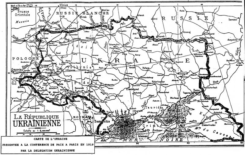
Deutsch: Grenzziehung der Ukrainischen Republik, wie sie von der ukrainischen Delegation auf der Pariser Friedenskonferenz 1919 präsentiert wurde
English: Map of Ukraine presented by Ukrainian delegation on Paris Peace Conference, 1919
Українська: Межі України, які були заявлені делегацією УНР на Паризькій мирній конференції в 1919-20 рр. |
| Kuupäev | 1919 |
| Allikas | direct source:Documents of Paris Peace Conference 1919 see also :"Akten zur deutschen auswärtigen Politik 1918-1945" Ser. A, 1918-1925. Bd. 1, 9. November bis 5. Mai 1919 Göttingen : Vandenhoeck und Ruprecht, 1982. |
| Autor | Government of ZUNR in name of ZUNR and UNR, official document of government of Ukraine |
| Teised versioonid |
|


Litsents
This file is a Ukrainian or Ukrainian SSR work and it is presently in the public domain in Ukraine, because it was published before January 1, 1954, and the creator (if known) died before that date (details).
|
 |
Faili ajalugu
Klõpsa kuupäeva ja kellaaega, et näha sel ajahetkel kasutusel olnud failiversiooni.
| Kuupäev/kellaaeg | Pisipilt | Mõõtmed | Kasutaja | Kommentaar | |
|---|---|---|---|---|---|
| viimane | 2. oktoober 2011, kell 03:48 | | 934 × 593 (305 KB) | Yerevanci | better version |
| 8. märts 2008, kell 04:49 |  | 934 × 593 (194 KB) | Riwnodennyk | {{Information |Description={{en|Map of Ukraine perposed by Ukrainian delegation on Paris Peace Conference, 1919}} |Source=[http://uk.wikipedia.org/wiki/Зображення:Carte_de_ukraine_1919.jpg Ukrainian Wikipedia] |
Faili kasutus
Seda faili kasutab järgmine lehekülg:
Globaalne failikasutus
Järgmised muud vikid kasutavad seda faili:
- Faili kasutus vikis be-tarask.wikipedia.org