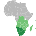
Fail:Southern African Development Community.svg

Selle SVG-faili PNG-vormingus eelvaate suurus: 600 × 600 pikslit. Teised eraldusvõimed: 240 × 240 pikslit | 480 × 480 pikslit | 768 × 768 pikslit | 1024 × 1024 pikslit | 2048 × 2048 pikslit | 1000 × 1000 pikslit.
Algfail (SVG-fail, algsuurus 1000 × 1000 pikslit, faili suurus: 184 KB)
Faili ajalugu
Klõpsa kuupäeva ja kellaaega, et näha sel ajahetkel kasutusel olnud failiversiooni.
| Kuupäev/kellaaeg | Pisipilt | Mõõtmed | Kasutaja | Kommentaar | |
|---|---|---|---|---|---|
| viimane | 23. juuli 2018, kell 13:34 |  | 1000 × 1000 (184 KB) | Ydecreux | Added Comoros |
| 21. november 2011, kell 14:59 |  | 1000 × 1000 (184 KB) | Htonl | color scheme | |
| 20. november 2011, kell 16:20 |  | 1000 × 1000 (184 KB) | Htonl | == {{int:filedesc}} == {{Information |Description=Map of Africa showing the member nations of the w:Southern African Development Community (SADC). Nations that are members of SADC and the w:Southern African Customs Union (SACU) are coloured dark |
Faili kasutus
Seda faili kasutab järgmine lehekülg:
Globaalne failikasutus
Järgmised muud vikid kasutavad seda faili:
- Faili kasutus vikis af.wikipedia.org
- Faili kasutus vikis ar.wikipedia.org
- Faili kasutus vikis ast.wikipedia.org
- Faili kasutus vikis bg.wikipedia.org
- Faili kasutus vikis ca.wikipedia.org
- Faili kasutus vikis cs.wikipedia.org
- Faili kasutus vikis en.wikipedia.org
- Faili kasutus vikis es.wikipedia.org
- Faili kasutus vikis eu.wikipedia.org
- Faili kasutus vikis fa.wikipedia.org
- Faili kasutus vikis fr.wikipedia.org
- Faili kasutus vikis hr.wikipedia.org
- Faili kasutus vikis id.wikipedia.org
- Faili kasutus vikis ko.wikipedia.org
- Faili kasutus vikis mg.wikipedia.org
- Faili kasutus vikis pl.wikipedia.org
- Faili kasutus vikis pnb.wikipedia.org
- Faili kasutus vikis pt.wikipedia.org
- Faili kasutus vikis sr.wikipedia.org
- Faili kasutus vikis sw.wikipedia.org
- Faili kasutus vikis tn.wikipedia.org
- Faili kasutus vikis vi.wikipedia.org
- Faili kasutus vikis www.wikidata.org
- Faili kasutus vikis zh.wikipedia.org
