
Fail:Europe 1918.jpg

Algfail (1444 × 1200 pikslit, faili suurus: 1,25 MB, MIME tüüp: image/jpeg)
| See fail ja sellest kastist allapoole jääv kirjeldus pärinevad kesksest failivaramust Wikimedia Commons. | Faili lehekülg Commonsis |
Lühikirjeldus
| Kirjeldus |
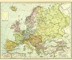
English: Map of Europe immediately after WWI. Pre-WWI borders are kept in color, while new states that emerged after WWI are presented in with red borders (see bottom of image). |
||||||||||||||||||||||
| Allikas | http://grossmanproject.net/Europe%20before%201918.htm | ||||||||||||||||||||||
| Autor |
|
||||||||||||||||||||||
Similar map by the same author: http://en.wikipedia.org/wiki/File:Distribution_of_Races_on_the_Balkans_in_1923.jpg
Litsents
|
See teos kuulub avalikku omandisse päritoluriigis ja teistes riikides, kus autoriõigus kehtib 70 aastat pärast autori surma või vähem.
| |
| Seda faili peetakse autoriõigusseadusest ning kõigist seonduvatest ja ligidastest õigustest tulenevalt teadaolevatest piirangutest vabaks. | |
and
This work is in the public domain because it was published in the United States between 1929 and 1963, and although there may or may not have been a copyright notice, the copyright was not renewed. For further explanation, see Commons:Hirtle chart and the copyright renewal logs. Note that it may still be copyrighted in jurisdictions that do not apply the rule of the shorter term for US works (depending on the date of the author's death), such as Canada (70 years p.m.a.), Mainland China (50 years p.m.a., not Hong Kong or Macao), Germany (70 years p.m.a.), Mexico (100 years p.m.a.), Switzerland (70 years p.m.a.), and other countries with individual treaties.
|
 |
Faili ajalugu
Klõpsa kuupäeva ja kellaaega, et näha sel ajahetkel kasutusel olnud failiversiooni.
| Kuupäev/kellaaeg | Pisipilt | Mõõtmed | Kasutaja | Kommentaar | |
|---|---|---|---|---|---|
| viimane | 27. september 2010, kell 22:36 | | 1444 × 1200 (1,25 MB) | Kentronhayastan | Edited a red mark that isn't supposed to be there on the original scan (little square mark that was added by the source from which I found this file). |
| 16. september 2010, kell 13:55 |  | 1444 × 1200 (862 KB) | Kentronhayastan | {{Information |Description={{en|1=Map of Europe immediately after WWI. Pre-WWI borders are kept in color, while new states that emerged after WWI are presented in with red borders (see bottom of image).}} |Source=Google search |Author=Unknown |Date= |Perm |
Faili kasutus
Seda faili kasutab järgmine lehekülg:
Globaalne failikasutus
Järgmised muud vikid kasutavad seda faili:
- Faili kasutus vikis ar.wikipedia.org
- Faili kasutus vikis arz.wikipedia.org
- Faili kasutus vikis azb.wikipedia.org
- Faili kasutus vikis en.wikipedia.org
- Faili kasutus vikis eo.wikipedia.org
- Faili kasutus vikis fr.wikipedia.org
- Faili kasutus vikis hu.wikipedia.org
- Faili kasutus vikis hy.wikipedia.org
- Faili kasutus vikis it.wikipedia.org
- Faili kasutus vikis ro.wikipedia.org